Cortez, Colorado, United States
Stay at Days Inn, 430 N State Hwy 145
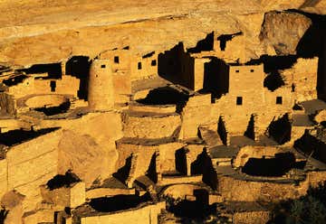
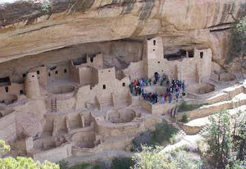
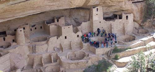
Tour starts at the Cliff Palace overlook on the Cliff Palace Loop Road. This one-hour tour descends 100 feet to Mesa Verde's largest and most famous cliff house. Along the way you must climb five 8–10 ft ladders.
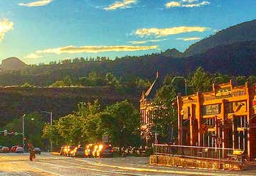
Where Old West meets Southwest, Downtown Durango is a Nationally Registered Historic District and home to historic boutique hotels, award winning restaurants, laid-back brewpubs, and fabulous art galleries, museums, and shops. Many of the original buildings constructed and used by the area's pioneers can be found in this interesting and charming section of town that includes the grand Strater Hotel, built in 1887 and still in operation today.
Stay at Super 8, 20 Stewart St in Durango

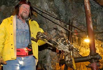
$26 each. Tours are every hour. 2,000 feet above the mine you can see the original 1904 miner's bunkhouse perched on the rocky cliffs of Galena Mountain. Once forty men and a cook lived in the three story structure, cabled to the rock wall so it wouldn't fall off! Nearby is the original #7 level tunnel where over 15,000 ounces of gold were produced from 1904- 1908. To get to the bunkhouse men rode a steep aerial tramline, riding buckets up, while the ore came down to the mill for processing. Men lived at the boardinghouse for weeks on end, except for payday when they rode the tram and the narrow gage train to Silverton for "a hot time in the old town"! By 1999 the old boardinghouse was about to disintegrate. Two-thirds of the roof was caved in due to years of heavy snow and neglect. But thanks to the co-operative efforts of the Old Hundred Gold Mining Company, the San Juan County Historical Society, the State Historical Society of Colorado, the Colorado Division of Minerals and Geology, the BLM, and some really gutsy carpenters (and helicopter pilot), the building will last many years to come. The unique boardinghouse and adjacent tramhouse are now an official State Historic Landmark. Learn more about the Old Hundred mine in the new book "Ghosts and Gold - The History of the Old Hundred Mine" by historian and geologist Scott Fetchenhier, available from The Miner's Commissary Gift Shop.
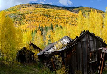
“a ghost town!” Ironton was a town in Ouray County, Colorado, United States. It lay south of the present town of Ouray. Ironton (aka Copper Glen) was built on flatter ground than surrounding towns. Settled in 1883, within three weeks three hundred buildings were being built. It was a staging area for supplies coming from Ouray. Ironton was a major transportation junction between Red Mountain Town and Ouray in addition to having some of its own mines. Ironton had a peak population of over 1000 and had two trains arriving daily from Silverton. There were many chain stores from the nearby cities of Ouray and Silverton. The town lived into the first part of the 20th century but slowly faded as mining operations declined. The final resident of the town, Milton Larson, died in the mid-1960s. The town site is still occasionally visited by tourists.
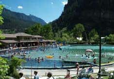
$14 day pass It's always a good day for a soak in the clear warm waters of the Ouray Hot Springs Pool! The hot springs of Ouray have been enjoyed since at least the 14th century when native Ute Indians used the naturally hot clear water for healing. Settlers came to the area in the late 1800's in search of gold and precious minerals, and many found comfort in the natural hot springs. The current swimming pool was constructed in the 1920's and has been a favorite destination ever since. Seven different springs supply the pool with water. At the source some of this water is 150 degrees! The pool consists of several sections maintained at different temperatures for different tastes. The hot section is approximately 104 degrees, and a soaking section, perfect for families and prolonged soaking, is typically 95 degrees, or so. The lap lanes and deep section are usually about 80 degrees in the summer and fall, and cooler than that in the winter months when there is snow on the ground. The Ouray Hot Springs Swimming Pool is an outdoor pool open all year. Many people enjoy the pool the most in the winter, after a day spent ice climbing, cross country skiing, snowshoeing, skating on the local ice rink (skates are available to rent at the Hot Springs Pool), or simply as a place to relax and enjoy the splendid scenery of the San Juan Mountains.
Montrose, Colorado, United States
Stay at Super 8 in Montrose, 1705 E Main.
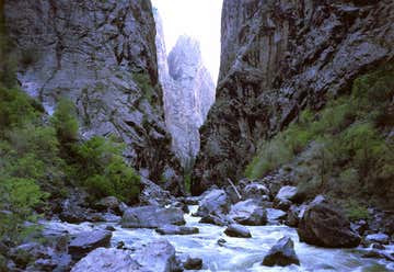
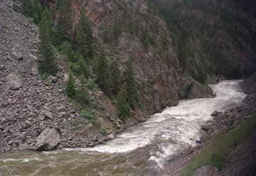
Big enough to be overwhelming, still intimate enough to feel the pulse of time, Black Canyon of the Gunnison exposes you to some of the steepest cliffs, oldest rock, and craggiest spires in North America. With two million years to work, the Gunnison River, along with the forces of weathering, has sculpted this vertical wilderness of rock, water, and sky. It has trails for all abilities are available on both South and North Rims. The canyon has been a mighty barrier to humans. Only its rims, never the gorge, show evidence of human occupation - not even by Ute Indians living in the area since written history began. While the people of the Ute bands knew of the Black Canyon of the Gunnison, it was an obscure geographic feature to explorers for hundreds of years. The Spanish were the first Europeans to canvas western Colorado with two expeditions, one led by Juan Rivera in 1765, and the other by Fathers Dominguez and Escalante in 1776. Both were looking for passage to the California coast, and both passed by the canyon.Fur trappers of the early 1800s undoubtedly knew of the canyon in their search for beaver pelts. They left no written record of the canyon, though, probably because they couldn't, in fact, read or write.By the middle of the century, exploration of the American west had captured the nation's attention. In turn expeditions came to the Black Canyon searching for railroad passageways, mineral wealth, or in a quest for water. Eventually explorers came to see the canyon, not for commercial wealth, but for the renewal and recreation that it offered. Today, you can walk in the footsteps of some of these hardy and inquisitive forebearers. The canyon still offers a rugged and demanding experience, even as it did more than a hundred of years ago.
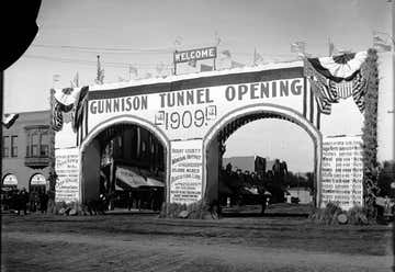
The Gunnison Tunnel is an irrigation tunnel constructed between 1905 and 1909 by the U.S. Bureau of Reclamation in Montrose County, Colorado. The 5.8 mile long tunnel diverts water from the Gunnison River to the arid Uncompahgre Valley around Montrose, Colorado. At the time of its completion, it was the longest irrigation tunnel in the world and quickly made the area around Montrose into profitable agricultural lands. In 1972, the tunnel was designated a National Civil Engineering Landmark by the American Society of Civil Engineers (ASCE). The idea for a tunnel is credited to Frank Lauzon, a miner and prospector. By the early 1890s he was farming in Montrose. Popular lore is that idea came to him in a dream that the waters of the Gunnison River should be brought to the valley. As construction was undertaken, two advances in technology made work safer and easier. Jackhammers fed by a compressor replaced hand-turned drill bits to set holes for blasting charges. Dynamite replaced black powder for blasting. By 1906 shifts of workers up to 30 at a time worked in the tunnel. The tunnel opened in 1909 to much fanfare with a dedication ceremony attended by President William Howard Taft.
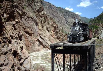
Cimarron Canyon trestle, October 2012 The Denver and Rio Grande Railroad's Cimarron Canyon trestle, listed as D&RG Narrow Gauge Trestle on the National Register of Historic Places, is a narrow-gauge railroad deck truss bridge crossing the Cimarron River, within the Curecanti National Recreation Area near Cimarron, Colorado. The bridge was built in 1895 by the Denver and Rio Grande Railroad, replacing a wooden trestle that was built sometime around 1882. The bridge was originally long but only a small portion of it remains today. Today this narrow-gauge trestle is the last remaining railroad bridge along the Black Canyon of the Gunnison route. The bridge has a steam locomotive, boxcar, and caboose on display – all of the Denver and Rio Grande Western Railroad gauge. The steam locomotive is D&RGW #278, a 2-8-0 built by Baldwin Locomotive Works in 1882. The D&RGW used the designation C-16 for this class of locomotive; the letter C stands for consolidation (2-8-0) and the 16 for the number of thousands of pounds of tractive effort of the locomotive, in this case, 16,000 pounds of tractive effort. The boxcar, D&RGW #3132, was built in 1904 by the American Car and Foundry. Caboose #0577 was manufactured in 1886.

Middle Bridge is the crossing of Blue Mesa Reservoir (the Gunnison River) on U.S. Highway 50 near Sapinero, Colorado. Prior to the construction of the Blue Mesa Dam, Rt. 50 did not cross the Gunnison River there, and a portion of the old highway can be seen descending into the lake. The bridge is located within Curecanti National Recreation Area

Monarch Crest Scenic Tram, $8 each, 10 minute ride up to 12,000'.
Monarch Pass is one of the most breathtaking and fun to visit high elevation mountain passes in Colorado. Located approximately a 30 minute drive west from Salida, Monarch Pass sits at 11,312 along the Great Continental Divide.
Onsite, there is a weather station, a gift shop, an aerial tram, and the Monarch Mountain Ski Resort. Monarch Pass was used as a filmed location for the Fast and Furious 7 movie, so see if you can catch the similarities.
Woodland Park, CO
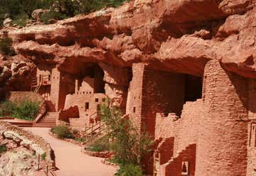
Unlike most cliff dwelling sites, the Manitou Cliff Dwellings site allows you to climb in and explore, enabling you to imagine the lives of the Native Americas who lived here. You get to experience the spaces that were used for cooking, ceremonies, sleeping, and living, with replica artifacts in place. Something about interacting with history like this makes you feel like a kid again, sparking curiosity and imagination. It’s also more accessible than Mesa Verde National Park since the dwellings were actually moved to this location to preserve them.
Explore the fascinating cliff dwellings architecture of the ancient Anasazi and browse through two museums featuring cultural displays all overlooking the historic town of Manitou Springs, Coloroda. Open 7 Days a Week (weather permitting) Closed Thanksgiving & Christmas The Manitou Cliff Dwellings is a rare historical treasure. Over 700 year old Authentic Anasazi cliff dwellings, with 40 rooms await you. There are no "Do Not Touch" signs. You are free to touch and even go inside these fascinating architectural remnants of an American Indian culture that roamed the Four Corners area of the Southwest from 1200 B.C. to A.D. 1300. The Manitou Cliff Dwellings is located in Manitou Springs, Colorado, at the foot of Pikes Peak, the mountain that provided the inspiration for the writing of, America the Beautiful. Over the years, Native American Indians - descendants of the Ancient Ones - have demonstrated their living culture through traditional dances handed down from generation to generation.
Silverthorne, Colorado, United States
Stay with Eric and Michelle, Stephen and Joan
Gore Canyon is a short isolated canyon on the upper Colorado River in southwestern Grand County, Colorado in the United States. The steep and rugged canyon, approximately 3 miles (5 km) long, was carved by the river as it passed the northern end of the Gore Range southwest of Kremmling. The Colorado descends from approximately 7300 ft to approximately 7000 ft over the length of the canyon. The steep walls ascend approximately 1000 ft on either side. The canyon effectively marks the southwestern end of the Middle Park basin in north central Colorado. The canyon is roadless and inaccessible by most traffic, except for the Union Pacific Railroad's Moffat Subdivision and whitewater boats. Despite the short length, the canyon presented a formidable obstacle for the railroad, and the building of the line through it was considered a monumental engineering achievement in its day. Although the canyon is not directly accessible by roads, it is possible to view part of the canyon from the Grand County road (CR 1, or Trough Road) that passes along its southern rim, as part of the Colorado Headwaters Scenic Byway. The California Zephyr also travels through the canyon. Gore Canyon is also famous for its wild class V whitewater. "Captain" Samuel Adams considered it unnavigable by boat during his expedition in the 19th century. The construction of the railroad has added boulders and other hazards that have since made the river even more difficult. Today, expert kayakers and rafters frequent the canyon, and now even hold a river festival including races and other river celebrations. The Gore Canyon Whitewater Festival is held every year on the third Saturday of August and is also the host of the US National White Water Rafting Championship. Gore Canyon was first rafted in the 1970s, and now is even available as a commercial river raft trip. Most outfitters agree that Gore Canyon's whitewater is the wildest commercially available whitewater rafting in the state of Colorado, and perhaps in the nation. Those who are brave enough to raft or kayak Gore Canyon will run rapids such as Pyrite, Tunnel Falls, and Gore Rapid. This is true wild water, so for those who are not expert river runners, Gore Canyon is considered a very dangerous section of the Colorado River.
Steamboat Springs, CO
Stay at WorldMark, 900 Pine Grove Circle
Banner Photo Credit: Roadglide2020
