At Glen Canyon Dam, the Carl B. Hayden Visitor Center is located 700 feet above the Colorado River overlooking Glen Canyon Dam and Bridge. The visitor center provides many interesting exhibits, audio-visual programs, and ranger presentations as well as a gift shop and an educational bookstore. Guided tours of Glen Canyon Dam and Powerplant are provided by the Glen Canyon Conservancy and begin at the visitor center.
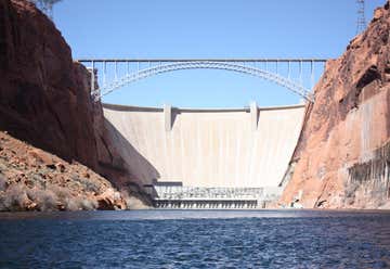
Glen Canyon Dam is a concrete arch dam on the Colorado River in northern Arizona in the United States, just north of Page. The dam was built to provide hydroelectricity and flow regulation from the upper Colorado River Basin to the lower. Its reservoir is called Lake Powell, and is the second-largest artificial lake in the country, extending upriver well into Utah. The dam is named for Glen Canyon, a colorful series of gorges, most of which now lies under the reservoir. The dam was proposed in the 1950s as part of the Colorado River Storage Project, a U.S. Bureau of Reclamation (USBR) federal water project that would develop reservoir storage on the upper Colorado River and several of its major tributaries. The project's main purpose was to allow the upper basin to better utilize its allocation of river flow as designated in the 1922 Colorado River Compact, and a second purpose was to provide water storage to ensure the delivery of sufficient water to the lower basin during years of drought. However, problems arose when the USBR proposed to build dams in the federally protected Echo Park canyon in Utah. After a long series of legal battles with environmentalist organizations such as the Sierra Club, they settled for a high dam at Glen Canyon. The construction of Glen Canyon Dam started in 1956 and was not finished until 1966. When the reservoir filled, the dam began to deliver a steady, regulated flow of water downstream and a supply of electricity to the region. In 1983, major floods nearly led to the dam's collapse, but disaster was averted by a close margin. By taming floods and other factors that once characterized Colorado, the dam has led to major physical and ecological changes in the lower river. Controversy continues over the effects both positive and negative of the dam, which has also been antagonized in many literary works.
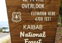
Kanab, Utah, United States
Fredonia, Arizona, United States

The drive down Highway 89A through the Vermilion Cliffs is absolutely breathtaking. It's incredible to see the huge cliffs on your left and realize that you're in the bottom of a ginormous basin that stretches all the way to the cliffs on your right. The magnitude of this area just blows your mind.
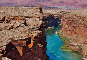
“one of only 7 land crossings over the Colorado River” Those traveling across the country on Highway 89A between Bitter Springs and Jacob Lake AZ arrive at two bridges similar in appearance spanning the Colorado River. These two bridges, one historic and one new, represent one of only seven land crossings of the Colorado River for 750 miles (1207 km). In the 1870’s, pioneers from Utah began to expand their settlements into northern Arizona. Nearly 600 miles (965 km) of deep canyons along the Colorado River stood in their way. One of the only places a wagon could reach the river from both north and south was at the mouth of Glen Canyon. Since the area was accessible and was a natural corridor between Utah and Arizona, a ferry was established there in 1873. Named after the first ferry operator, John D. Lee, Lees Ferry became an important route for pioneers, settlers and local traffic. In the 1920’s, automobiles began using the ferry as a means to cross the Colorado River. It was recognized that it was time to find a safer, more reliable way for vehicles to cross. A bridge site was selected 5 miles (8km) downriver at Marble Canyon. Construction of the bridge began in June of 1927. This was rugged and remote country and it was difficult to get men, materials and equipment from one rim to the other, a distance of only 800 feet (244m). The ferry was used to transport materials when possible. However, on June 7, 1928, the ferry sank in an accident which killed three men. Since the bridge known then as Grand Canyon Bridge was nearing completion, the ferry was not replaced. So, for the nextseveral months, no direct route existed between Utah and Arizona. People had to travel 800 miles (1287km) around the canyon to reach the other side of the river. It was an historic day when, on January 12, 1929, the bridge was opened to traffic. At the time, it was the highest steel arch bridge in the world and made traveling between Utah and Arizona much easier. No longer did travelers have to contend with the moods of the Colorado River at Lees Ferry. The dedication of the bridge took place June 14-15, 1929. For such an isolated spot, it was an astounding event. Nearly 7,000 people in 1,217 automobiles arrived for the celebration. Speeches were given by the governors of Arizona, New Mexico, and Utah and by the President of the Mormon Church. Bands, choral groups, and Native American dancers were also a part of the festivities. It was reported that airplanes flew under the bridge and as Prohibition was in effect, the bridge was christened with a bottle of ginger ale. The bridge was known as the Grand Canyon Bridge for five years following the dedication. In 1934, after great debate in the Arizona legislature, the official name was changed to Navajo Bridge.
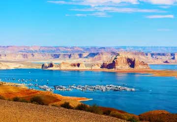
Wahweap Overlook was a spur of the moment stop we made while exploring around Lake Powell. We were trying to find a good spot to stop and admire the views (without having to pay $30 to do so), and after a few miles north on Highway 89 we saw the turn-off for Wahweap Overlook. We were really impressed with what we saw once we got out!
From Wahweap Overlook, you can see Wahweap Marina, Glen Canyon Dam, Navajo Generating Station, and miles of dramatic shoreline of Lake Powell! There is a covered picnic bench and several large rocks near the edge of the Overlook, so you may want to get there early if you want to take advantage of these prime spots!
I was surprised by the lack of crowds here, but then again I was here a couple of hours before sunset so I can’t speak to crowds at a later time. However, I super suggest visiting this place around sunset for the dramatic views and colors on the distant rock walls! This was a nice break from the overly crowded Antelope Canyons and Horseshoe Bend, and the best part about it was it was free!
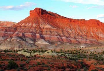
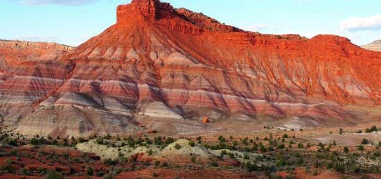
Definitely hit this up! The pull-off comes up a bit fast and after the directions. When you get there you definitely should drive down the road into the little canyon. Hardly anyone there and the views are gorgeous. Pahreah, also referred to as Old Paria, is a ghost town nestled along the Paria River in the Grand Staircase - Escalante National Monument in Kane County, Utah. Pahreah was inhabited from 1870 until 1929 and was later used as a filming location for many western movies. Today little remains of the town or the movie set because all the buildings have either collapsed, burned, or washed away in flood waters. The mountains surrounding Pahreah are layered in alternating bands of red, purple, white, and a bluish grey. It's a great stop to take in amazing views and to envision scenes from the Wild West.
The area was first settled in 1865 by a Mormon group led by Peter Shurtz. Shurtz constructed a strongly built sandstone house that led to this settlement's name, Rock House. After the Black Hawk War ended in 1867, settlers began showing up to this settlement at a rapid pace. This settlement thrived for several years until half the residents decided to move 5 miles upriver due to a failing water supply and frequent attacks from Native Americans. This move formed the townsite of Pahreah in 1870, and homes were built and crops were planted. The town thrived and reached a population of 130, consisting of 47 families including 20 Paiutes. The town then began to face hard times starting in 1883 when the Paria River flooded every year for 5 years, washing away buildings and crops. The population dwindled due to the frequent flooding until only eight families remained in 1892. A short time later, in 1893, the town gained a post office under the name Paria. Not much changed in Paria until 1912, when a small gold mine was established. Unfortunately, the mine was also decimated by flood waters and closed within a year. The post office closed in 1915, and the town was empty by the 1930s.
In later years, movie and television crews became interested in using the abandoned town and its picturesque background to film westerns. In 1943, producers filmed several scenes for "Buffalo Bill" here. As roads were built and tourism increased, producers for several other movies and television programs continued to use the area for filming from the 1940s throughout the 1970s, even though crews were in a constant struggle with the flooding Paria River. Then, in 1962, the old ghost town was chosen as the location for a Rat Pack film, "Sergeants 3," which was the largest western ever filmed in Kane County. The producers of this film were not satisfied with what remained of Pahreah, so they decided to build an imitation town just a mile away from the original townsite. This imitation town was then used for filming until 1976, when it fell into disuse after the filming of "The Outlaw Josey Wales," starring Clint Eastwood. In 1998, more flooding badly damaged the set. A team of volunteers dismantled what was left of the set and built replica buildings between 1999 and 2001, also installing signs to explain the historical significance of this site. The rebuilt set met its demise in 2006 when it was burned down by a suspected arson fire.
Today you can reach the Pahreah day-use area by following a dirt road for approximately 4.6 miles. This section of road is generally well maintained, but use caution if it is wet. Once you reach the day-use area you will see a large fenced-in parking lot and a wooden outhouse. You can also find placards telling the history of the town and movie site. The road continues for a mile past the day-use area until it reaches the banks of the Paria River. This portion of the road is generally extremely rough or impassible due to frequent flooding. You have to cross a dry wash several times and pass the cemetery, which houses approximately 20 graves, before reaching the edge of the river.
To reach the original townsite, you will have to park and hike across the river. The road to the day use area can become impassible when they are wet. A high-clearance four-wheel drive vehicle may be able to make it beyond the first stream bed crossing, but be prepared to get out and walk the final distance to the site.
