
8116 Carrick Lane, Springfield, Virginia, United States
Arrive at Unell's, pack up and leave the next morning.
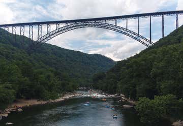
“a work of structural art” When the New River Gorge Bridge was completed on October 22, 1977, a travel challenge was solved. The bridge reduced a 40-minute drive down narrow mountain roads and across one of North America's oldest rivers to less than a minute. When it comes to road construction, mountains do pose a challenge. In the case of the New River Gorge Bridge, the challenge was transformed into a work of structural art - the longest steel span in the western hemisphere and the third highest in the United States.
The New River Gorge Bridge is one of the most photographed places in West Virginia. The bridge was chosen to represent the state on the commemorative quarter released by the U.S. Mint in 2006. In 2013, the National Park Service listed the New River Gorge Bridge in the National Register of Historic Places as a significant historic resource.
Recommendation: From the visitor center, we went down a lot of steps to an overlook of the bridge from below. After taking our time getting back up, we checked out the visitor center, which was super informative and has a room full of photographs and history.
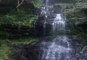
About a mile east of Gauley Bridge you’ll find Cane Branch, a small tributary of the New River.
What is Cathedral Falls?
Cathedral Falls is a beautiful 60+ foot waterfall on Cane Branch. It cascades down a narrow canyon and lands right beside US Rt 60. This creek begins on Gauley Mountain and makes a short but exciting trip to the New River. It actually drops nearly 100 feet over a series of Upper Nuttall sandstone ledges, but the final 60 feet of drops are the ones you can see from the roadside park.
For the technology junkies who love to use GPS, the coordinates for Cathedral Falls are 38.15444N by 81.1788W.
Why You Should Go
There’s a magic quality to water, whether it’s sitting motionless or flowing through a stream. Cathedral Falls is a special place to visit if you’re traveling around southern West Virginia. The sounds of the water falling over the rocks can help you reconnect with nature and forget about your worries for awhile.
And Cathedral Falls is also a wonderful spot for photographs. Tucked away in its own little canyon, you’ll have a hard time taking a bad picture here. You can go to Cathedral Falls many times and your photos will always be different. The water flow changes all the time.
And be sure to pack a picnic lunch; there’s no prettier spot to enjoy a meal. The roadside park has a couple of tables, and with a little exploring you can see more of the falls than just what you can view from the road.Cathedral Falls is a beautiful 60+ foot waterfall on Cane Branch. It cascades down a narrow canyon and lands right beside US Rt 60. This creek begins on Gauley Mountain and makes a short but exciting trip to the New River. It actually drops nearly 100 feet over a series of Upper Nuttall sandstone ledges, but the final 60 feet of drops are the ones you can see from the roadside park.
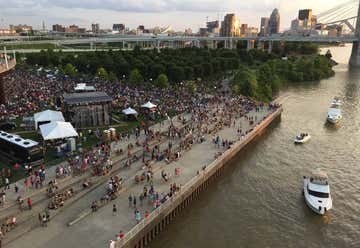
The Waterfront isn't just a place, it's an experience. An experience that's different for everyone. We're a peaceful oasis in the heart of the city. We're a natural haven for quiet reflection. We're an ongoing festival of sounds and sights. We're your favorite band blasting into the night sky. And we're right here, accessible to all.

Trilobites and brachiopods If you’re fossil-hunting in eastern Kansas, you’re more likely to find fossils from the Pennsylvanian time period, around 300 million years ago. “[If you] want to go somewhere today that looks like what Kansas was like in Pennsylvanian time, [it’s the] Florida Keys,” Buchanan says. The shallow waterways are teeming with invertebrate life like brachiopods (an ancient shellfish similar to a mollusk), corals, and the occasional trilobite (a marine arthropod that looks a little like a roly-poly bug).
So how do you get started on your own family fossil-hunting adventure? Ancient creatures left their mark all over the country, so you might be able to find something in your neck of the woods. Buchanan suggests watching for road cuts on highways, then exiting onto smaller country roads nearby to find a road cut that’s safe to access. Of course, you need to be careful of traffic and don’t hunt on private property without permission.
Near Lawrence, you can try the spillway at Clinton Lake, a car-free zone with a broad walking path. Sandy shales along the spillway’s edges hold invertebrates. Sometimes fossils just “weather out” and you can pick them up off the ground. You might even find a brittle sea star if you’re lucky.
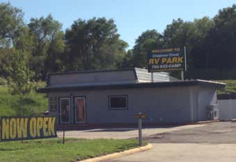
CampLife Logo Thank you for choosing Chapman Creek RV Park Guest Yenna Colvin Arrival Date 05/25/2021 Departure Date 05/26/2021 Confirmation Code 27481068 Site Details Site Name Deer Bluff 15 Site Type Pull Through Site Max Length 66ft. Site Max Width 27ft. Directions to Site On top of bluff, farthest west. Pull in from the west
Site Description 2 trees on each side, grass, picnic table. Motorhome 39 ft or less. NO with TOW for this site
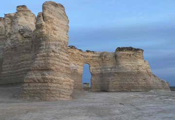
The Chalk Pyramids and Monument Rocks are names for the same group of rock outcroppings, near US-83 in western Kansas. There are signs at the turn off (6 miles of gravel roads). You can see the rocks in the distance from the highway if you know where to look. Like the Castle Rock Badlands, the Monument Rocks are on private range land, but thanks to the owners, open to the public. The United States Department of the Interior has designated the Chalk Pyramids as a National Natural Landmark. The 70 feet tall sedimentary formations of Niobrara Chalk were created 80 million years ago when this area was part of a vast inland sea.
Monument Rocks and Castle Rock are an 8 Wonder of Kansas as a duo entry because of the scientifically significant fossils these ancient chalk beds have produced and because they have been highly eroded into unusual spires and shapes, making them spectacular landmarks on the plains of western Kansas!
On the western edge of Gove County is Monument Rocks, a series of large, heavily sculpted chalk monoliths that are sometimes referred to as the Chalk Pyramids. The site has been designated as a National Natural Landmark. In eastern Gove County is Castle Rock, a chalk spire that stands by itself in the valley of Hackberry Creek, though immediately south of Castle Rock is an extensive outcrop of chalk, capped by the younger Ogallala Formation.
The chalk was deposited during the Cretaceous Period of geologic history, about 80 million years ago, when the central interior of the U.S. was covered by a seaway. The several hundred feet deep water contained single-celled animals that drifted to the sea floor for eons, creating a mucky ooze. This material was perfect for trapping and preserving the remains of animals that lived in that ocean, such as fish, turtles, sharks, swimming reptiles called mosasaurs and plesiosaurs, swimming birds, gliding reptiles called pterosaurs, as well as invertebrate animals such as giant clams. Today the chalk beds routinely give up these fossils. Probably the best-known fossil from these beds is the famous "fish-within-a-fish" on display at the Sternberg Museum in Hays.
Both places are on private property but the landowners are amenable to visitors and no special permission is required. Please be respectful!
PLEASE NOTE: The following is not allowed - no climbing, fossil hunting, camping, littering or bonfires. Do not honk at cattle. Please take only pictures and leave only footprints.
Keystone Gallery is near Monument Rocks and is a good place to see and visit about fossils. Located on U.S. 83, 26 miles south of Oakley or 18 miles north of Scott City.
DIRECTIONS:
Castle Rock: Take I-70 Quinter exit 107 (Castle Rock Road), go 15 miles south to the intersection of GO 80 and GO K, then 4 miles east to Castle Rock sign, and north across a cattle guard (dry weather road only).
Monument Rocks: 20 miles south of Oakley on U.S. 83, then 4 miles east on Jayhawk Road, 3 miles south, and 1 mile east (dry weather road only). Or, 18 miles north of Scott City, east 2 miles on Dakota Road, 1 mile north, 3 1/2 miles east, and 2 1/2 miles north.
7088 Red Mesa Drive, Littleton, Colorado, United States
Ryan's House


May 31
