


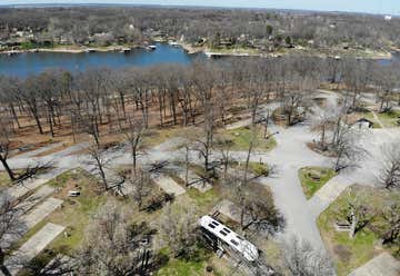
Snake Creek From Muskogee, 21 mi southeast on OK 10, 7 mi east on OK 10A., Gore OK 74435 GPS: 35.648, -94.973 $$, 112 sites, Apr 1-Sep 30, All ages, Tents, 100 ft max RV length, 637 ft elev, 7 pull thrus, 5 full hookups, 104 electric only sites, 30/50 amp, 50 50 amp sites, tables, grill, water, toilets, showers, dump, playground, beach, boat launch, (C)
Chicken Creek From Muskogee, 21 mi southeast on OK 10, 7 mi east on OK 10A., Gore OK 74435 GPS: 35.683, -94.96 $$, 101 sites, Jan 1-Sep 30, All ages, Tents, 100 ft max RV length, 690 ft elev, 37 electric only sites, 64 elec-water hookups, 30/50 amp, 50 50 amp sites, tables, grill, water, toilets, showers, dump, RV Storage, playground, beach, boat launch, (C)
ALL CGs IN AREA ARE STATE PARK SITES
Homeland Grocery 1300 S York St, Muskogee, OK 74403

via S 655 Rd
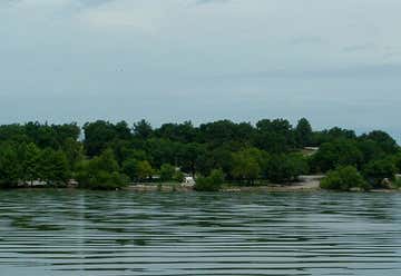
Twin Bridges State Park Located 6 miles east of Fairland at junction of Hwy 137/60., Fairland OK 74343 GPS: 36.80249, -94.756348 $$, 163 sites, All Year, All ages, Tents sites: 100, 810 ft elev, 4 pull thrus, electric, 63 elec-water hookups, 30 amp, tables, grill, water, toilets, showers, dump, playground, fish, boat launch, (C)
Morse Park (Neosho) From the Neosho town square, take East Spring Street east a few blocks. Facilities are located along Hickory Creek between Highway 86 and College Street., Neosho MO 64850 GPS: 36.881963, -94.371316 free, All Ages, Tents, electric, water, toilets, dump, playground, fish, Although under MDC, the RV area is maintained by City of Neosho (C)
White Ranch Conservation Area N Central 1 From West Plains, take Highway 17 south 7.5 miles, then County Road White
Ranch Conservation Area SE 2 From West Plains, take Highway 17 south 7.5 miles, then County Road 8390 south 5 miles to the area., West Plains MO 65775 GPS: 36.525252, -91.76953 free, 1 sites, All Year, All Ages, Tents, 920 ft elev, fish, (C)8390 south 5 miles to the area., West Plains MO 65775 GPS: 36.563384, -91.850318 free, 1 sites, All Year, All Ages, Tents, 920 ft elev, fish, (C)
PUBLIC DUMP STATION 7TH AVE SW Walmart Neighborhood Market 2426 S Maiden Ln, Joplin, MO 64804
Aldi Groc 2551 Lusk Dr, Neosho, MO 64850
Aldi Grocery 1210 Missouri Ave, West Plains, MO 65775
Watercress Campground Mark Twain NF, Take Highway 60 to Van Buren. In Van Buren, proceed along US60/Main Street to the National Park Service Office on Watercress Road; follow the black-topped road past the Office; making a left turn to the bottom of the hill, approximately 1/3 mile., Van Buren MO 65401 GPS: 36.999742, -91.019028 $, 17 sites, Apr-Oct, 50 ft max RV length, 459 ft elev, tables, grill, toilets,
Big Spring RV Camp 501 East Chicopee Rd, From Jct of US-60 & Hwy 103, S 0.3 mi on Hwy 103 to E Chicopee Rd, E 0.3 mi, Van Buren MO 63965 GPS: 36.98755, -91.009179 $$$, 50 sites, late May-Lab Day, 70 ft max RV length, 478 ft elev, Accepts Big Rigs, 50 full hookups, electric, 20/30/50 amp, 50 50 amp sites, tables, grill, water, dump, Clubs-GSC, laundry, firewood, internet, cable tv,
Main Street Market 308 Main St, Van Buren, MO 63965
Winona, Missouri, United States
Watercress Campground Mark Twain NF, Take Highway 60 to Van Buren. In Van Buren, proceed along US60/Main Street to the National Park Service Office on Watercress Road; follow the black-topped road past the Office; making a left turn to the bottom of the hill, approximately 1/3 mile., Van Buren MO 65401 GPS: 36.999742, -91.019028 $, 17 sites, Apr-Oct, All ages, Tents, 50 ft max RV length, 459 ft elev, tables, grill, toilets, pet friendly extra rules, (C)
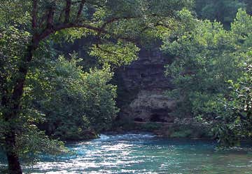
Ozark NSR - Hickory Landing , Ellsinore MO 63937 GPS: 36.891282, -90.910582 $, All Year, All Ages, Tents, 400 ft elev, toilets, trail, hike (C)
Ellington, Missouri, United States
Eminence, Missouri, United States
Round Spring, Missouri, United States
Salem, Missouri, United States
Cherryville, Missouri, United States
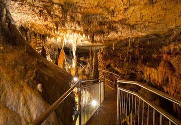
Onondaga Cave State Park ***** 7556 Highway H, From I-44 & Hwy H (Leasburg Exit), go 7 mi SE on Hwy H., Leasburg MO 65535 GPS: 38.055999, -91.23324 $$, 66 sites, All Year, All ages, Tents, 740 ft elev, 2 pull thrus, electric, 47 elec-water hookups, 50 amp, 50 50 amp sites, tables, grill, water, dump, laundry, firewood, playground, (C)
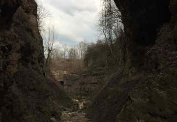
Huzzah Conservation Area From Leasburg, take Route H south 5 miles to the area., Leasburg MO 65535 GPS: 38.023281, -91.200989 free, 16 sites, Sep 15-May 15, All Ages, Tents, 680 ft elev, toilets, fish, trail, hike, (C)
Walmart 100 Ozark Dr, Cuba, MO 65453
Dillard, Ironton, Missouri, United States
Land Between the Lakes Recreation Area Many choices.
Nickell Branch Lake Access CG $$ 36.98719, -88.20133
Twin Lakes CG $ 36.96534, -88.19813 Demumbers Bay Denumbers Bay Lake Access, Kuttawa KY 42055 GPS: 36.977419, -88.15416 , All Year, All Ages, Tents, 385 ft elev, dispersed (C)
Nearest Campgrounds: by straight line GPS/air Hillman Ferry - 2.56 mi / 4.12 km Twin Lakes - 2.56 mi / 4.13 km Nickell Branch Lake Access - 2.69 mi / 4.32 km Canal Campground - 3.34 mi / 5.37 km Eureka - 3.98 mi / 6.40 km Smith Bay - 4.66 mi / 7.50 km Crockett Frontier Campground - 5.11 mi / 8.21 km
Food Giant 720 Fairview Ave, Eddyville, KY 42038
Garden of the Gods Road, Equality, Illinois, United States
Elizabethtown, Illinois, United States
Cave-in-rock State Park New State Park Rd. Cave-in-Rock IL GPS: 37.469001, -88.156106 $$, 59 sites, All Year, All ages, Tents sites: 25, 60 ft max RV length, 400 ft elev, 34 electric only sites, 30 amp, tables, grill, water, toilets, showers, dump, pet friendly, playground, trail, hike, restaurant (C)
Tower Rock Area Tower Rock Rd, Elizabethtown IL 62919 GPS: 37.458334, -88.230735 , All Ages, Tents, 350 ft elev, dispersed (C)
Bob's Food Marth 421 Main St, Rosiclare, IL 62982
Hopkinsville, Kentucky, United States
