

The White River Entrance to Mount Rainier National Park is a complex of buildings built between 1929 and 1931 to accommodate visitors arriving on the Yakima Park Highway, in the northeastern portion of the park. Like most of the structures in Mount Rainier, the buildings are designed in the National Park Service Rustic style, using natural stone and log materials. The historic district includes the 1933 Men's Mess Hall and Dormitory, believed to be the only surviving camp structure built by the Civilian Conservation Corps in the park. The Ranger and Checking Station was built starting in 1929. Access was difficult, since Yakima Park Highway construction had not yet reached the area. Work was not entirely completed until 1931. Design was by the National Park Service Branch of Plans and Design, under the supervision of Thomas Chalmers Vint. The station is a one-story T-shaped log structure of seven rooms, with a porte-cochere extending over the road. It follows the prototype of the Nisqually Entrance Station, although the Nisqually station was remodeled to incorporate the porte-cochere first used at White River. The building provided living and working quarters for a ranger, with two bedrooms, a dining room, kitchen bathroom and living room. Men's and women's "comfort stations," or public toilets, were built nearby in 1931 in a similar style. The district was listed on the National Register of Historic Places on March 13, 1991. It is part of the Mount Rainier National Historic Landmark District, which encompasses the entire park and which recognizes the park's inventory of Park Service-designed rustic architecture.
Add to Trip
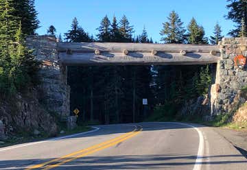
The Chinook Pass Entrance Arch marks the east entrance to Mount Rainier National Park. The rectangular log entry arch is one of several placed at the entrances to the park. It was designed in 1933 by the National Park Service Branch of Plans and Designs, and was built in 1936 by the Civilian Conservation Corps. The arch consists of two stone abutments carrying horizontal logs over the road. The arch functions as a bridge, carrying a horse trail, which is now part of the Pacific Crest Trail. The Chinook Pass arch was placed on the National Register of Historic Places on March 13, 1991. It is part of the Mount Rainier National Historic Landmark District, which encompasses the entire park and which recognizes the park's inventory of Park Service-designed rustic architecture.
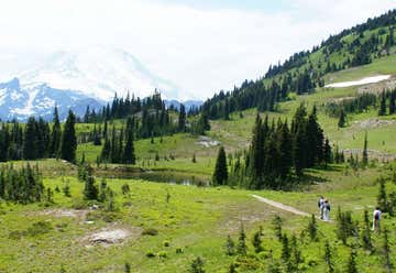
Park at Tipsoo Lake, .5 mile west of Chinook Pass on SR 410. For a clockwise hike of the Naches Peak Loop Trail, follow the trail from the picnic area to Chinook Pass and the Pacific Crest Trail. This easy loop is one of the most popular hikes in the park. It starts out along the Pacific Crest Trail at Chinook Pass and leads south, traversing the east side of Naches Peak 1.6 miles until intersecting the Naches Loop Trail. To continue the loop and return to Tipsoo Lake in 1.4 miles, follow the Naches Loop Trail along the west side of Naches Peak. An option for hikers with a bit more time and energy is to proceed on the Pacific Crest Trail from the junction to Dewey Lakes, an additional one mile round trip. This short hike is well worth the extra time and effort. To get the best views of Mount Rainier, hike the loop in a clockwise direction This loop provides the hiker with breathtaking views of the Mountain, a look at beautiful subalpine meadows, and an abundant supply of huckleberries in late summer and early fall. There is no camping along the Naches Peak Loop Trail within Mount Rainier National Park. Nor are there any suitable sites for camping along the Pacific Crest Trail within the park. Camping is permitted on adjacent United States Forest Service lands. Elsewhere within Mount Rainier National Park camping opportunities exist both in designated trailside camps and crosscountry areas. Permits are required for camping. Pets are allowed only on the Pacific Crest Trail portion of the loop. Dogs are not allowed on other portions of the Naches Peak Loop Trail, nor are they allowed on any other trail inside the park. Dogs are allowed in the national forest section of the Pacific Crest Trail, but must be leashed. Fires are prohibited. Treat water before drinking.
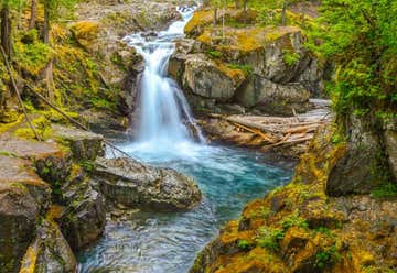
Careening over a series of ledges before plunging 40 feet into a deep blue pool, Silver Falls is a dramatic sight. And it’s easily accessible. A very short trail leads to it from SR 123. But the best way to experience this cascading spectacle on the Ohanapecosh River is by hiking to it on a delightful loop from the Ohanapecosh Visitors Center. En route you’ll pass the site of an old hot springs resort, some big old trees, an overhanging mossy ledge, and perhaps a surprise or two. Distance, round trip: 3 miles Elevation gain: 300 feet Hiking time, round trip: 1.5 hours

The Morton Depot Visitor Center is open to everyone looking for information on the surrounding area including Mt. Rainier and Mt. St. Helens. Open daily, 11am - 4pm, beginning May 31. Closes at the end of September for the winter.
Located next door to the Historic Morton Depot, the visitor center offers local information on the top locations to fish, hike, enjoy water sports, or discover the myriad of recreation activities near the White Pass Ski Area, Mt. Rainier and Mt. St. Helens. The friendly staff is happy to direct you to nearby services and attractions.
Morton, Washington, United States
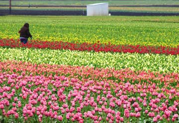
Visitors are welcome at the Bulb Farm throughout the year. You can stroll through the gardens free of charge and visit the front greenhouses to see what is in production. Our western Washington garden center has something to offer plant enthusiasts all year.
Marys Corner, Washington, United States
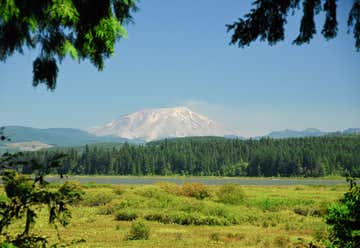
“Shaken by an earthquake measuring 5.1 on the Richter scale, the north face of this tall symmetrical mountain collapsed in a massive rock debris avalanche. Nearly 230 square miles of forest was blown down or buried beneath volcanic deposits. At the same time a mushroom-shaped column of ash rose thousands of feet skyward and drifted downwind, turning day into night as dark, gray ash fell over eastern Washington and beyond. The eruption lasted 9 hours, but Mount St. Helens and the surrounding landscape were dramatically changed within moments.” The Mount St. Helens Visitor Center opened its doors to the public a few years after the monumental eruption of Mount St. Helens. Functioning as a gateway to the mountain, over 30 miles away, our goal is to educate visitors on the historical significance of the landscape before and during the eruption. We also focus on the resulting impact on nearby ecosystems. Our vantage point offers a view of the Western slope of the mountain, visible from both our center and walking trail. This unique building features expansive windows providing a glimpse of towering second-growth forest all around. A high archway and elaborately carved wooden columns contribute to the feeling of magnificence. Inside, visitors can enjoy a variety of interpretive displays that include comprehensive information on local history, geology, and re-growth and recovery of the land in the years immediately after the eruption.
Displays include:
Large, step-in model of the volcano
Life-size mannequins
functioning seismograph and live feed of current Mount St. Helens volcano seismicity
Chronological timeline of events leading up to the volcanic blast on May 18, 1980
Theater program offered twice an hour; at :05 and :35 after.
Outdoors, visitors can explore Silver Lake along the 0.6 mile-long trail, including boardwalks over the wetland where a variety of aquatic plants and migratory waterfowl can be viewed at different times of the year.
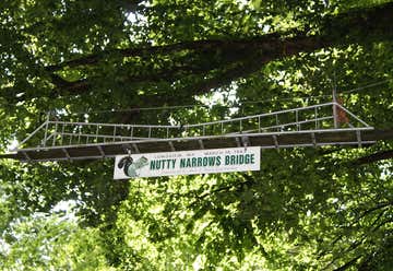
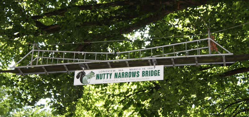
A bridge built for squirrels!
After witnessing so many cute, little squirrels getting hit by cars while attempting to cross Olympia Way, to make it to the land of nuts and honey (i.e. the heavily-wooded Civic Center area), Amos Peters decided to do something about it. So, in 1963 he helped establish a sky-bridge over Olympia Way. Tacoma councilwoman named the bridge Nutty Narrows Bridge, after the Tacoma Narrows Bridge. The 60-foot-long mini-suspension bridge was mad with aluminum and a “retired firehose”. It cost $1,000. Peters had been caring for the bridge for decades, when in 1983 he had to take it down for repairs. When it was completed, over 300 children and local politicians attended the re-dedication ceremony along with “special guests Chip 'n' Dale and Mickey Mouse from Disneyland.” A year later, Amos died. In his memory the town built a 10-foot wooden squirrel sculpture in his honor. Currently the bridge stands 100 yards down from its original location, and connects R. A. Long Park at the Civic Center with the Longview Public Library. In 2013, the Longview City Council deemed the bridge worthy of a place on the Longview Register of Historic Places. Since the original bridge was constructed, two more bridges were built for safe squirrel passage, one on Kessler Blvd and one of Nichols Blvd. -Roadtrippers The Nutty Narrows Bridge is a squirrel bridge in Longview, Washington. It has the title of the "World's Narrowest Bridge" and also the "World's Narrowest Animal Crossing." The Nutty Narrows was named by a local councilwoman after the Tacoma Narrows Bridge.
Kelso, Washington, United States
