
The stops that are turned on, are to keep to 5-6 hour driving days, if we are willing to drive further each day, we can change which hotels are turned on/off. If we drive to Boise the first day (assuming we don't get as early a start leaving portland as when we just leave a hotel) it could be a 6 hour drive on day one, and 7.5-8 hour days x3 days to be here in 4 days.
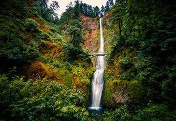
3758 Northwest Bronson Crest Loop, Portland, Oregon, United States
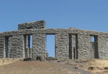
Sun - Sat: 7:00 am - 8:00 pm The Maryhill Stonehenge was the first monument in the United States to honor the dead of World War I (specifically, soldiers from Klickitat County, Washington who had died in the still on-going war). The altar stone is placed to be aligned with sunrise on the Summer Solstice. Hill, a Quaker, informed that the original Stonehenge had been used as a sacrificial site, and thus constructed the replica as a reminder that humanity is still being sacrificed to the god of war.

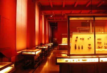
Tue - Sat: 10:00 am - 4:00 pm Umatilla County is at the hub of transportation routes east-west and north-south, used by Indian tribes, explorers, trappers, pioneers, and travelers of today. The region’s varied terrain and abundant natural resources attracted people whose diverse traditions, ingenuity and perseverance have made it their "home". Indian tribes, mountain men, missionaries, and emigrants have all made their mark on this region. Heritage Station, The Umatilla County Historical Museum, is telling the story of this region’s unique heritage. It’s a BIG story, so exhibits are not static. They change often to portray local history from a variety of perspectives, utilizing historic objects and information from the museum archives.

Mon - Sat: 10:00 am - 5:30 pm Sun: 11:00 am - 4:00 pm Correction to the Tours, there are 4 each day Monday through Friday they start at 9 AM 11 AM 1:30 PM and 3 PM. All of the tours are free
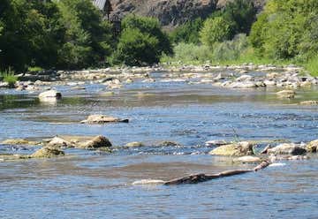
"3 miles of easy walking trail” Step onto the Pendleton River Parkway and step into nature. Almost three miles of flat trail takes you through the heart of Pendleton along the banks of the Umatilla River. Take a few minutes to explore other city landmarks along the way. For suggestions from locals, keep scrolling down. Restrooms are located along the Parkway at Roy Raley Park, Stillman Park and Brownfield Park.
The Baker Heritage Museum will reopen for the season on March 17, 7days a week and from 9am to 4pm. Admission: Adults (18+) $6.00 The completely renovated and restored 1889 Italianate home was the residence of Baker City philanthropist, Leo Adler, for 94 years
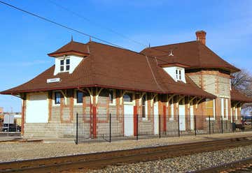
In the fall of 1882, four people filed claims on four sections of land, four corners of which touched two blocks west of the depot. The purpose of this action was to bargain with the railroad for this location of the depot by offering up land. Ontario was born with the arrival of the railroad in 1883. Prior to that, Winnemucca Nevada, 150 miles away, was the closest railroad available for coast-to-coast passenger, livestock and freight service. In the fall of 1883, the first depot was constructed. It was a small rectangular building that provided passenger services, freight services and small living quarters. On January 1, 1884, Ontario had its first railroad service. In 1907 the present sandstone and brick building was erected.


It took a little over two years and more than 430 pounds of spare change to make it happen, but Randy Miller's vision finally became a reality.On a sunny Saturday afternoon, he put the finishing touches on what he hopes will be a new tourist destination in the city's downtown area that literally took shape one penny at a time. A local artist, Miller transformed a plain, cinder block wall of Kurly's sports bar and grill into a mural composed of spare pocket change. Known as the Penny Wall, it covers the upper half of the roughly 46-by-16 foot alleyway wall. "I'm glad it's done because there's a lot of meaning behind it," Miller said. In addition to having people come out and view this new display, he hopes it'll also encourage folks to stop by the different shops and businesses in this part of town. "If this helps Mountain Home, then I'm all for that," he said. The Penny Wall project started in August 2010 when Miller started collecting the gallons of pennies, nickels, dimes and quarters needed to create the Mountain Home-specific artwork.

This one has a viewing deck, looks pretty awesome
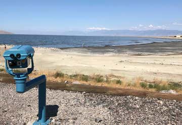
Open Hours: The visitor center is free of charge and is open: 7 days per week April - September: 7am to 8pm The center features an open-air pavilion, boardwalk trail through prime birdwatching habitat, and a 30-foot-high observation tower. From a dirt parking lot, visitors can access bathrooms (with running water and modern plumbing), then the boardwalk over the wetland begins. The trail, which is elevated to keep your feet dry, is a flat, one-mile loop. With the exception of the observation tower, the entire trail and visitor center is wheelchair accessible. or check out caches an antelope island, susan wants to see the great salt lake, sounds cool, looks like those may have better view than this site
hours: Mon–Thu · 9am–9pm Fri–Sat · 9am–6pm Sun · 1–5pm Top level viewing deck with 360 view. This is also the library that Uncle Mike did much of his genealogy research.
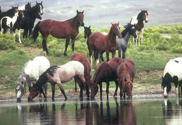
The 24-mile self-guided Pilot Butte Wild Horse Scenic Tour can begin in either Green River or Rock Springs. Watch for wild horses between Rock Springs and 14-Mile Hill, and all the way across the top of White Mountain. Although this is a relatively dry area with sparse vegetation, it is also home to a variety of wild animals, including pronghorn, elk, deer, rabbits, coyotes, hawks, eagles and sage-grouse, among others. Wildlife viewing is best in the early morning and late afternoon hours.
There are caches all along the drive
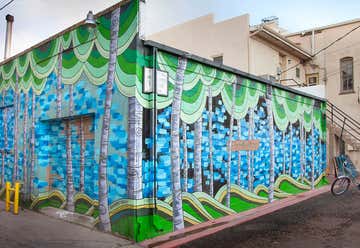
Since 2011 the Laramie Mural Project has worked with local artists and the UW Art Museum to paint a series of large scale murals through the historic district that are reflective of Laramie's cultural and social assets. Take a walking tour of each mural by picking up a guide at the Laramie Main Street Alliance, 207 Grand Ave. or the Tourism Board (Visit Laramie) at 210 Custer. When taking photos, be sure to use the hash tag #laramiemural multiple geo caches around town, not a lot of favorite points, one big travel hotel with 43 favorite points.
Free Admission The Conservatory Wed - Sun 10:00 AM - 5:00 PM Closed Mon - Tues The Grounds Always open from dawn to dusk The Cheyenne Botanic Gardens (9 acres, 3.6 ha) are located in Lions Park in Cheyenne, Wyoming, with an associated High Plains Arboretum located five miles (8 km) northwest of Cheyenne at an elevation of 6,200 feet (1,900 m). The gardens began as a vision in 1977 to build a non-profit, solar heated greenhouse. Today, the 6,800 square foot (630 m) conservatory consists of three greenhouses. The first is filled with tropical plants, herb and cacti gardens, and a waterfall pond filled with Koi fish. The second is used primarily for growing vegetables, with beds of lettuce, onions, cabbages, broccoli, carrots, etc. The third is focused on propagation of bedding plants and flowers for the botanic garden grounds and all flowers for the Cheyenne park system. Outside are many gardens featuring perennials, annuals, wildflowers, roses, herbs, and cacti.
In the extreme southwest corner of the county, thirty three miles from Kimball, rises the highest point in Nebraska. Panorama Point, 5,424 feet above sea level, looks more like a rise in a pasture than the highest point in the State; however this site is higher than the highest point in 30 other states. Art Henrickson and Claude Alden discovered the highest point in October 1951 using a WWI altimeter. A marker was installed by the Kimball-Banner Chamber of Commerce in 1971. It was later verified by the federal government and recognized by the state and mapping companies. GPS Coordinates N 41 degrees 00.461 minutes W 104 degrees 01.883 minutes Panorama Point has become quite a popular attraction. Please bear in mind, this is on private property. There is a box for your entrance fee. Drive slowly and carefully, this is definitely a rustic track. However, the drive is worth it. On a clear day you can see the Rocky Mountains to the southwest and enjoy the prairie peacefulness of the great Nebraska Plains. A guest registration book is kept at the marker and visitors are asked to sign in. Upon request, those who visit will be issued a certificate issued by the Kimball-Banner County Chamber of Commerce.
