“Trek across a volcanic alpine landscape of dramatic contrasts – steaming vents, glacial valleys, ancient lava flows, alpine vegetation and vivid crater lakes, all with stunning views.”
This challenging trip begins at 1120 m, climbs the Mangatepopo Valley to the saddle between Mount Tongariro and Mount Ngauruhoe, through South Crater before climbing again to Red Crater, the highest point on the crossing at 1886 m.
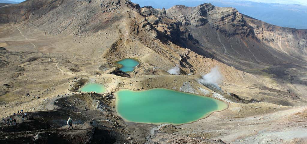
You will then descend on a volcanic rock scree track to the vivid Emerald Lakes, known as Ngarotopounamu (greenstone-hued lakes). After passing Blue Lake, also known as Te Wai-whakaata-o-te-Rangihiroa (Rangihiroa’s mirror), the track sidles around the northern slope of Tongariro, then descends in a zigzag track past Ketetahi Shelter and down to the road end at 760 m.
Be prepared for a long and challenging day out.
There is now a 4 hour parking restriction in place at Mangatepopo road end to allow for those doing shorter walks. However, for those hiking the entire Tongariro Alpine Crossing, licensed operators who are approved by the Department of Conservation, will not only provide timely shuttle transport but also provide expert safety knowledge on the walk and the weather plus free parking at their depot. They will also provide back-up should you suffer a mishap during the day.
Reviews
Be the first to add a review to the Tongariro Alpine Crossing.
/175.6668406,-39.0660611,14/300x172@2x?access_token=pk.eyJ1Ijoicm9hZHRyaXBwZXJzIiwiYSI6ImNsdjQ5N2VtZDA2bW8ycW13ZHAxeGhjbjkifQ.UIccpoAxc7g3BAuK4s9vjg)
Tongariro Alpine Crossing
Hours
- Sun - Sat: 12:00 am - 11:59 pm
Problem with this listing? Let us know.
Has RV parking changed? Let us know.
-
Parking
-
Pets Allowed
-
Restrooms
-
Wifi
-
Wheelchair Accessible
-
Credit Cards Accepted
Parking
Nearby Hotels
Related Trip Guides
- Trip Guide
Wellington to Gisborne Long Weekend Roadie
- 18 Places
- 19:22
- 826 mi
- Trip Guide
Cycle The Otago Central Rail Trail
- 34 Places
- 04:20
- 169 mi
- Trip Guide
Great Alpine Highway
- 29 Places
- 10:42
- 414 mi
- Trip Guide
New Plymouth to Gisborne Long Weekend Roadie
- 12 Places
- 14:06
- 621 mi