“home to a rich diversity of landscapes& ecology”
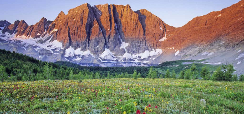
Established in 1920, Kootenay National Park represents the south-western region of the Canadian Rocky Mountains. From glacier-clad peaks along the Continental Divide to the semi-arid grasslands of the Rocky Mountain Trench, where cactus grows, this park is home to a rich diversity of landscapes and ecology. Kootenay National Park is located in southeastern British Columbia Canada, covering 1,406 km2 (543 sq mi) in the Canadian Rockies, and forms part of a World Heritage Site. The park ranges in elevation from 918 m (3,012 ft) at the south-west park entrance, to 3,424 m (11,234 ft) at Deltaform Mountain. Kootenay forms one of the four contiguous mountain parks in the Canadian Rockies; the other three being Banff National Park directly to the east, Yoho National Park directly to the north, and Jasper National Park, which does not share a boundary with Kootenay National Park. Initially called "Kootenay Dominion Park", the park was created in 1920 as part of an agreement between the province of British Columbia and the Canadian federal government to build a highway in exchange for title (property) to a strip of land on either side of the route. A strip of land 8 km (5.0 mi) wide on each side of the newly constructed 94 km. Banff-Windermere Highway was set aside as a national park. While the park is open all year, the major tourist season lasts from June to September. Most campgrounds are open from early May to late September, while limited winter camping is available only at the Dolly Varden campground. The park takes its name from the Kootenay River, one of the two major rivers which flow through the park, the other being the Vermillion River. While the Vermillion River is completely contained within the park, the Kootenay River has its headwaters just outside of the park boundary, flowing through the park into the Rocky Mountain Trench, eventually joining the Columbia River. The Banff-Windermere Highway, #93 follows the path of both rivers through the park. The park's main attractions include the Hot Springs, Olive Lake, Marble Canyon, Sinclair Canyon and the Paint Pots. The hot springs offer a hot springs pool ranging from 35°C to 47°C (95°F to 117 °F). The Paint Pots are a group of iron-rich cold mineral springs which bubble up through several small pools and stain the earth a dark red-orange colour. The Paint Pots were a major source of the ochre paint pigment for a number of First Nations groups prior to the 20th century. Because of the relatively small width of the park (five miles on each side of the highway), many of the park's attractions are situated near the road and are wheelchair accessible. A number of recent forest fires in the northern half of the park in the Simpson River, Vermillion Pass, and Floe Creek areas in 2003 and 2004 have left significant burn areas readily visible from the highway. Numa Falls is a short drive south of Marble Canyon (Canadian Rockies) and is accessible directly by Highway 93 which cuts through the park. Just outside the park's south-western entrance is the town of Radium Hot Springs. The town is named for the odourless hot springs located just inside the park boundary. The name originated at the turn of the 20th century when the promoters tried to sell the hot springs as a therapeutic cure and used the springs' very slight radioactivity as a selling point. The area around the hot springs is also home to the rubber boa snake. The park's north-eastern entrance, connects to Castle Junction in Banff National Park and the Trans-Canada Highway via Vermillion Pass, a mountain pass across the Continental Divide of the Canadian Rockies on the Alberta/British Columbia border, at an elevation of 1,651 metres (5,416').
Reviews

Lots of adorable wildlife to see at this park. Like this mama bear that saves her baby from traffic! :)

This park is fantastic. Beautiful scenery throughout. Make sure to stop at the hot springs if you are entering from the southwest side! Wildlife is extremely abundant here.
The park actually has an app you can download that is linked to your GPS and gives you a guided tour as your drive along. It's actually pretty helpful since there is no cell service in the park. Make sure to turn it on before you enter.

The backdrop of this National Park is incredible. Peaceful, not crowds and tons of sceneries and wild animals along the way before entering tran-Canada highway.

Have never been in a hot springs...would love to check it out.
Be the first to add a review to the Kootenay National Park.
/-116.04865,50.88305,14/300x172@2x?access_token=pk.eyJ1Ijoicm9hZHRyaXBwZXJzIiwiYSI6ImNsdjQ5N2VtZDA2bW8ycW13ZHAxeGhjbjkifQ.UIccpoAxc7g3BAuK4s9vjg)
Kootenay National Park
Hours
- Sun - Sat: 9:00 am - 11:00 am
Problem with this listing? Let us know.
Has RV parking changed? Let us know.
-
Parking
-
Pets Allowed
-
Restrooms
-
Wifi
-
Wheelchair Accessible
-
Credit Cards Accepted
Nearby Hotels
Related Trip Guides
- Trip Guide
Toronto to Tobermory: Exploring Ontario's shores and natural wonders
- 10 Places
- Trip Guide
Prince Edward Island: Tour this tiny island filled with big adventures
- 11 Places
- Trip Guide
Fort Providence: An idyllic town at the edge of civilization
- 10 Places
- Trip Guide
Explore Alberta's Rockies from Edmonton to Canmore
- 15 Places