“protecting the tortoises”
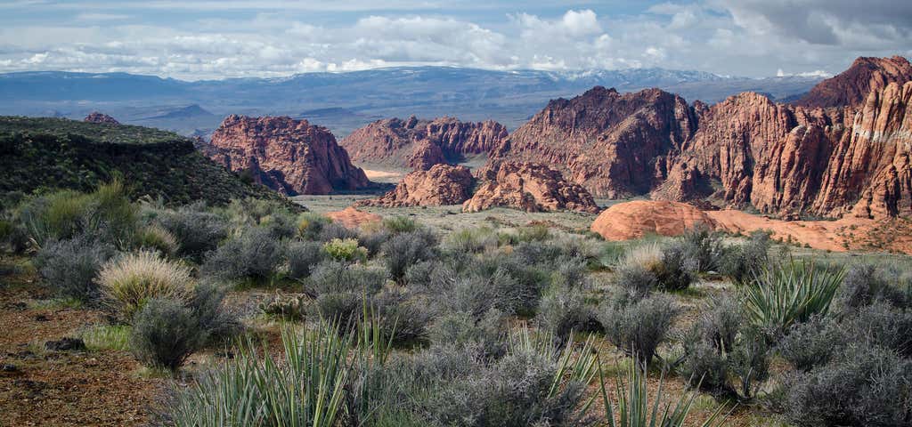
The Red Reef trail is comprised of three segments, each very different from the others and with very different user requirements. The most popular segment starts out of the Bureau of Land Management’s Red Cliffs campground 1 mile west of Interstate 15 at Harrisburg. This trail is relatively easy and used by large numbers of the general public during the spring and fall seasons when weather is pleasant. It follows the Quail Creek drainage out of the campground and enters a winding, beautiful red rock canyon with numerous opportunities for general recreation. All but the first hundred yards or so are located in the Cottonwood Canyon wilderness area which is closed to bicycles. Hikers will find the single track trail segment easy in most parts with some hilly spots until ½ mile up the canyon visitors must navigate around a large pool of water over an 8-foot sandstone wall with carved-out foot holds (locally called Moki steps) with assistance from an anchored rope. It is unclear who, if anyone, maintains the security of the rope; thus, hikers use it at their own risk. The pool is often used as a favorite swimming hole with jumpers, acting at their own risk. Jumping or diving into pools along any portion of the creek is not recommended and can cause serious injury or worse due to shallow water and hidden obstacles. From there the canyon continues up stream through a long slot and multiple dry falls, often filled with water during wet season or after rains. The creek flows constantly during the spring season but often shuts down later in the year. Hikers will get wet unless they choose somewhat difficult climbs above the drainage to circumvent the deepest pools. This should only be done by persons knowledgeable of the safest routes. At about 1½ miles from the campground trailhead, the designated trail route diverts to the left (south) up an unnamed side canyon at a spot that is not well marked other than by a user-created cairn. This is the second segment. This drainage will take visitors up to a high saddle and allow eventual access to the third and southern trail segment leading down to the Cottonwood trailhead. The side canyon is less than 1 mile in length and involves numerous dry falls (sometimes referred to as pour-overs) with pools at their bottom that need to be circumvented within the steep, narrow walls of the canyon. This will be an extreme challenge for many hikers who are not comfortable with steep slopes on red slickrock and who are uncomfortable with heights. At a point about ¼ mile from the turn off, it is necessary to navigate a 30-foot narrow, vertical chimney with a single, user-installed rope to get beyond a large dry fall. Use the rope at your own risk inasmuch as its safety and maintenance is unknown. The climb requires physical dexterity, upper-body strength, and a cool mind, among other attributes helpful in a canyoneering environment. It is highly recommended that this entire extreme but spectacular segment not be taken without a knowledgeable guide who has been through the canyon before. An alternative, but undesignated, route used by a few hiking groups to the upper saddle involves taking the side canyon to the left immediately after the Moki steps at the large pool. This canyon, however, involves significant rock scrambling over large boulders throughout its length and is considered dangerous by agency personnel and hiking guides. This route has contributed to a large number of injuries over the years. It is considered an extreme segment and is not recommended for the general public. Once on top of the saddle, visitors will enjoy outstanding views of red and white sandstone cliffs and broad expanses of checkerboard slickrock, much of it easily accessible to hikers of all abilities. Over the next half mile or so, visitors should follow the western edge of the saddle south as the land slopes gently downward toward the southern canyon complex that will take them to the last segment of the trail. Most drainages, faint user trails, and a few user-built cairns will guide hikers to the narrow canyon which consists of numerous slots, small dry falls and beautiful red rock formations. Once into the canyon, hikers will travel a winding, easy to moderately difficult route about 3½ miles to reach the Cottonwood trailhead, finishing the hike on the eastern-most portion of the Cottonwood Canyon trail. The entire trail can be taken in reverse order starting at the Cottonwood trailhead (often used when hiking only the southern segment – a popular and fun alternative involving a four mile hike up through the high saddle before turning around to return to Cottonwood) or done as a loop hike by returning to the Red Cliffs area via the northern segment of the Prospector trail (10 plus miles total). When hiking the entire trail out of the Cottonwood trailhead, the entrance to the middle canyon segment is readily found by staying against the west side of the upper saddle and following the drainage that drops off to the north. No signage is posted to assist in locating its position. Elevation at the Red Cliffs campground is about 3220 feet, at the highest point on the upper saddle about 3760 feet, and at the Cottonwood trailhead about 3280 feet. Total up and down elevation change is about 1700 feet for the entire one way hike. The connecting side canyon and a half mile of the upper Quail Creek drainage lie inside the Cottonwood Forest wilderness area on the Dixie National Forest. The remaining portions of the trail lie on lands administered by the Bureau of Land Management in the Cottonwood Canyon wilderness area inside the boundaries of the Red Cliffs NCA.
Be the first to add a review to the Red Cliffs Desert Reserve.
/-113.5809194,37.1084456,14/300x172@2x?access_token=pk.eyJ1Ijoicm9hZHRyaXBwZXJzIiwiYSI6ImNsczF1Y3RwcTA0ZmgycHAwbngweHlmbDAifQ.G6RP_RvWmMx8yNQSHb3PGQ)
Red Cliffs Desert Reserve
Hours
- Sun - Sat: 8:00 am - 5:00 pm
Problem with this listing? Let us know.
Has RV parking changed? Let us know.
-
Parking
-
Pets Allowed
-
Restrooms
-
Wifi
-
Wheelchair Accessible
-
Credit Cards Accepted
Parking
Nearby Hotels
Related Trip Guides
- Trip Guide
Pay Tribute and Reflect at These US Monuments and Memorials
- 14 Places
- Trip Guide
The top things to do on an I-40 road trip
- 35 Places
- 49:44
- 2,851 mi
- Trip Guide
The top things to do on an I-10 road trip
- 55 Places
- 56:13
- 3,026 mi
- Trip Guide
The ultimate road trip guide to Canyonlands National Park
- 18 Places