“on the way to the Mount Hood Meadows Ski Area”
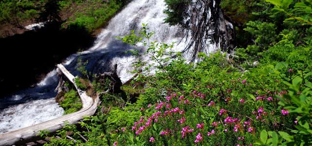
The 3.4 mile long Umbrella Falls Trail travels from the junction of the Timberline Trail, across the Mount hood Meadows access road, passing Umbrella Falls, onto its eastern endpoint at the junction of the Elk Meadow Trail near Hood River Meadows. To reach the falls, travel on the trail about 1/4 mile northeast from the Mt. Hood Meadows Access road. The portion of the trail west of the access road provides easy access to magnificent mountain views and floral displays and is ideal for those unable to visit the rough terrain generally found around the timberline. From the access road, the trail climbs gradually uphill, first through a forested area, then through the open meadows located in the ski area. The well defined tread leads through the open meadows whose floral displays include Indian paintbrush, cat's ears, lupine, bistort, western pasque flower and avalanche lilies early in the season. The trail crosses Mitchel Creek in 1.1 miles and terminates at its junction with the Timberline Trail #600. Directions from Sandy: Travel east on Highway 26 to Highway 35. Follow 35 northeast to the access road for the Mount Hood Meadows Ski Area (about 15 miles past Government Camp). The trailhead is located 0.2 miles below the gated entrance to the ski area and is marked with a sign.

The 3.4 mile long Umbrella Falls Trail travels from the junction of the Timberline Trail, across the Mount hood Meadows access road, passing Umbrella Falls, onto its eastern endpoint at the junction of the Elk Meadow Trail near Hood River Meadows. To reach the falls, travel on the trail about 1/4 mile northeast from the Mt. Hood Meadows Access road. The portion of the trail west of the access road provides easy access to magnificent mountain views and floral displays and is ideal for those unable to visit the rough terrain generally found around the timberline. From the access road, the trail climbs gradually uphill, first through a forested area, then through the open meadows located in the ski area. The well defined tread leads through the open meadows whose floral displays include Indian paintbrush, cat's ears, lupine, bistort, western pasque flower and avalanche lilies early in the season. The trail crosses Mitchel Creek in 1.1 miles and terminates at its junction with the Timberline Trail #600.
Be the first to add a review to the Umbrella Falls Trail.
/-121.6539674,45.3193151,14/300x172@2x?access_token=pk.eyJ1Ijoicm9hZHRyaXBwZXJzIiwiYSI6ImNsczF1Y3RwcTA0ZmgycHAwbngweHlmbDAifQ.G6RP_RvWmMx8yNQSHb3PGQ)
Umbrella Falls Trail
Hours
Problem with this listing? Let us know.
Has RV parking changed? Let us know.
-
Parking
-
Pets Allowed
-
Restrooms
-
Wifi
-
Wheelchair Accessible
-
Credit Cards Accepted
Nearby Hotels
Related Trip Guides
- Trip Guide
A road trip to filming locations featured in 'The Goonies'
- 6 Places
- 00:57
- 28 mi
- Trip Guide
The Ultimate Guide to Crater Lake National Park
- 15 Places
- Trip Guide
- Weekend
Pacific Coast Highway: Oregon - Washington
- 30 Places
- 17:36
- 670 mi
- Trip Guide
The top things to do on a U.S. Route 20 road trip
- 23 Places
- 60:25
- 3,576 mi