“walk in the footsteps of gold rush miners!”
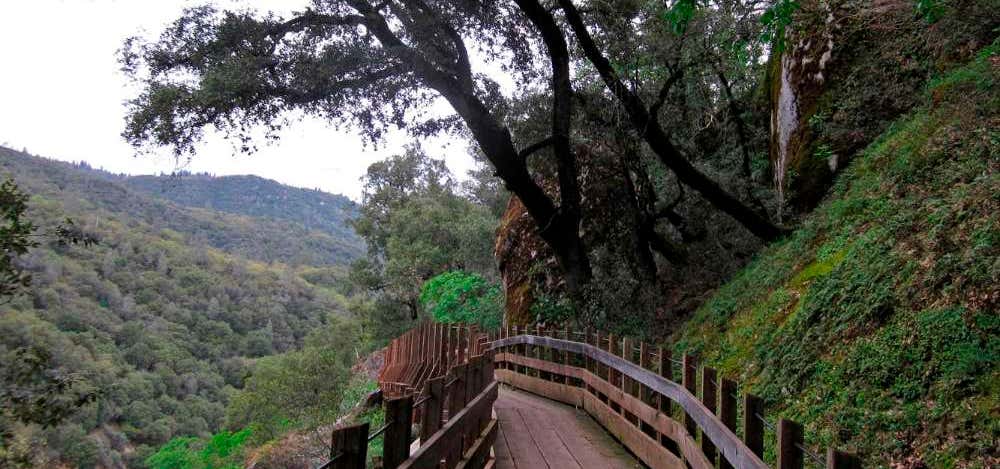
Founded by the late John Olmsted, the Independence Trail transformed an historic gold mining ditch into the nation’s first identified handicapped-accessible wilderness trail. It is now one of the most popular trails in the area, contouring along wooded hillsides, passing live streams, and crossing deep gorges on restored wooden flumes that once transported water for hydraulic mining. The trail has two separate sections — West and East — that extend from one main trailhead on Highway 49. Independence Trail West is oriented for most of its length around the canyon of Rush Creek, a large tributary stream that enters the South Yuba River at Jones Bar. The West trail features several wooden flumes, picnic tables and benches. Flume 28, over 500′ in length, crosses above a waterfall on Rush Creek 1.1 miles west of the trailhead. It is a “must see” piece of mining history. Place: South Yuba River State Park about 6 miles west of Nevada City, CA Season: Year around Land: Mixed state, federal and non-profit organization Trail signs: Trailheads and various features (e.g. flumes) are well marked on the main trail. Length: West trail 2.5 mi one way. For a longer option, this trail can be combined with Independence Trail East. Altitude change: West trail nearly level (50′) Difficulty: Easy. The West Trail is wheelchair accessible in dry months from the trailhead to a short way beyond Flume 28 (about 1.1 miles one way). Trail surface: Native Soil Environment: Mixed conifer, hardwood and riparian forest along river canyons Rules: Dogs on leash; no bicycles or motorized vehicles; no smoking or fires; no camping Trailhead: From the north end of Nevada City where Highway 49 turns west toward Downieville, go 6.25 miles on Hwy 49 north. A highway sign tells northbound travelers the Independence Trailhead is coming up. There is parking along the east side of Highway 49 by the trailhead, and overflow parking just around the next curve down Highway 49. In the parking area look for a “Trail Entrance” sign, display case and restrooms on your right (N39.29164 W121.09734). For Independence Trail West, go to the right southwest at the display case, walk about 100′ and pass under Highway 49 via a low-ceiling pedestrian underpass measuring 60 feet long by 58 inches high. The trail continues west from there. The wooden ramp that extends to Rush Creek is unsafe and closed. Do not enter. A bit of history: The Independence Trail utilizes the old Excelsior Ditch, built around 1859 to bring high pressure water for hydraulic mining. The ditch tapped the South Yuba River more than two miles upstream from here and ran all the way to what is now the dam at Lake Wildwood, then by the China Ditch to the Smartsville mining district, 15 miles west of Grass Valley, CA. Trail Tips: The most popular section of this trail is the first mile, going out to see the viewpoint (0.4 mile) and the impressive Flume 28 over Rush Creek (1.1 mile) with its waterfall and cascades, especially in wet months. Flume 25 and Flume 26 (at 0.8 and 0.9 mile) are impressive too. There are several benches along the way and a nice picnic table by the closed Diamond Outhouse (0.5 mile). About 0.1 mile beyond Rush Creek, after Flume 28, there is a decaying wheelchair camping deck with picnic tables and a closed outhouse. Practical wheelchair access ends at this point.

Unfortunately, we lost this trail in a wildfire last year, it no longer exists.
Be the first to add a review to the Independence Trail.
/-121.030519966523,39.2660699138591,14/300x172@2x?access_token=pk.eyJ1Ijoicm9hZHRyaXBwZXJzIiwiYSI6ImNsdjQ5N2VtZDA2bW8ycW13ZHAxeGhjbjkifQ.UIccpoAxc7g3BAuK4s9vjg)
Independence Trail
Hours
Problem with this listing? Let us know.
Has RV parking changed? Let us know.
-
Parking
-
Pets Allowed
-
Restrooms
-
Wifi
-
Wheelchair Accessible
-
Credit Cards Accepted
Nearby Hotels
Related Trip Guides
- Trip Guide
Pay Tribute and Reflect at These US Monuments and Memorials
- 14 Places
- Trip Guide
The Ultimate Guide To Joshua Tree National Park
- 53 Places
- 11:44
- 408 mi
- Trip Guide
The top things to do on an I-40 road trip
- 35 Places
- 49:44
- 2,851 mi
- Trip Guide
The top things to do on an I-10 road trip
- 55 Places
- 56:13
- 3,026 mi