“A local gathering spot”
place in Oregon listed on National Register of Historic Places

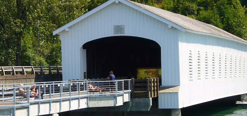
Amos Hyland settled on the Middle Fork of the Willamette River in 1874 and plotted the small town of Lowell. Hyland operated a ferry across the Willamette near the present site of the Lowell Covered bridge, until a bridge was first built in 1907. That bridge was replaced in 1945 after a truck accident knocked the truss out of alignment. In 1947, the structure was housed. The entire bridge was raised 6 feet in 1953 in anticipation of the flooding produced by Dexter Dam. Calculations about the height of water were correct and the water level has never risen closer than 2 feet from the bottom of the bridge. The bridge was bypassed by a concrete bridge in 1981. Prior to its closing, a dump truck traveling with its bed up caused extensive damage to the bridge. Lane County replaced broken roof braces and portal boards. A sign in Lowell City Park commemorates the covered bridge.

Lowell Bridge is not where this marker says it is. It's on Pioneer as you cross the lake leaving Lowell.
Be the first to add a review to the Lowell Bridge.
/-122.7796,43.9099,14/300x172@2x?access_token=pk.eyJ1Ijoicm9hZHRyaXBwZXJzIiwiYSI6ImNsczF1Y3RwcTA0ZmgycHAwbngweHlmbDAifQ.G6RP_RvWmMx8yNQSHb3PGQ)
Lowell Bridge
Hours
Problem with this listing? Let us know.
Has RV parking changed? Let us know.
-
Parking
-
Pets Allowed
-
Restrooms
-
Wifi
-
Wheelchair Accessible
-
Credit Cards Accepted
Nearby Hotels
Related Trip Guides
- Trip Guide
A road trip to filming locations featured in 'The Goonies'
- 6 Places
- 00:57
- 28 mi
- Trip Guide
The Ultimate Guide to Crater Lake National Park
- 15 Places
- Trip Guide
- Weekend
Pacific Coast Highway: Oregon - Washington
- 30 Places
- 17:36
- 670 mi
- Trip Guide
The top things to do on a U.S. Route 20 road trip
- 23 Places
- 60:25
- 3,576 mi