“Get away from it all”
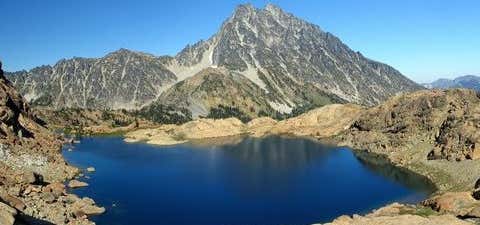
Sometimes you just want to get high--physically, not psychedelically--and the Lake Ingalls Trail lets you do that while still exploring some of the grandest wildflower displays in the Cascades. You'll climb, descend, and climb again, crossing through no less than three distinct ecosystem types, each with its own species of wildflowers to entice and enchant you. As with the Longs Pass Trail you'll start out on the old miners road leading up the Teanaway Valley. Within the first 0.25 mile the wide roadbed fades to a true trail. It also splits, the path to the left heading to Esmeralda Basin and Fortune Creek Pass. Go right to start your climb out of the Teanaway Valley. You'll be hiking through the first flora stratum you'll encounter on this hike, with huckleberry bushes, a few lilies, and other lesser known flowers, such as pipsissewa and wintergreens. At 2 miles go left at another trail junction (right leads to Longs Pass). The trail angles upward, climbing steadily and at times steeply. As you near Ingalls Pass the trail meanders through a rock-strewn meadowland. Along the long, slow climb to the pass you'll enter a drier ecosystem full of alpine firs. Bitterroot, white paintbrush, penstemon, and spreading stonecrop (a pretty little succulent plant) grow in profusion. The final 0.3 mile switchbacks up to Ingalls Pass, about 3 miles from the trailhead. Here you'll enjoy spectacular views of Ingalls Peak across the Ingalls Creek valley in front of you, and Esmeralda Peaks across the Teanaway River valley behind you. The trail now descends briefly before contouring around the upper flank of Headlight Basin. As you crest the pass and descend into the rocky basin, you'll enter rich heather meadows filled with bistort, paintbrush, and--in one spring-fed ravine--a 10-acre spread of shooting stars. This lush valley sports many fine campsites alongside small tarns and creeks in the open heather and flower fields. Of course, an abundance of rich foliage and plenty of water means birds and animals frequent this basin. Move silently and watch carefully for the best chances to see deer, mountain goats, marmots, coyotes, and countless bird species. After gawking, pop your eyes back into your head and push on--the next mile swings around the upper edge of the basin, crossing a few creeks and weaving around some nice ponds. As you leave the flowers you'll traverse a broad granite slope and climb up and over a tangle of granite slabs and boulders before dropping to rock-rimmed Lake Ingalls. Views are hard to come by here--rock hard, that is. Swing out to the left as you reach the lake and drop down to rest on the long rock slabs that taper down into the water. From here, look across the mirror-finish lake to the magnificent face of mighty Mount Stuart to the north, while the craggy top of Ingalls Peak towers directly over the lake on the west.
Be the first to add a review to the Lake Ingalls Trail.
/-120.9003723,47.2705294,14/300x172@2x?access_token=pk.eyJ1Ijoicm9hZHRyaXBwZXJzIiwiYSI6ImNsczF1Y3RwcTA0ZmgycHAwbngweHlmbDAifQ.G6RP_RvWmMx8yNQSHb3PGQ)
Lake Ingalls Trail
Hours
Problem with this listing? Let us know.
Has RV parking changed? Let us know.
-
Parking
-
Pets Allowed
-
Restrooms
-
Wifi
-
Wheelchair Accessible
-
Credit Cards Accepted
Nearby Hotels
Related Trip Guides
- Trip Guide
The Great Northern is a 3,600 mile, cross-country odyssey
- 57 Places
- 69:15
- 3,565 mi
- Trip Guide
- Weekend
Pacific Coast Highway: Oregon - Washington
- 30 Places
- 17:36
- 670 mi
- Trip Guide
The ultimate guide to North Cascades National Park
- 13 Places
- Trip Guide
Olympic National Park is 1,400 sq miles of primeval beauty
- 14 Places