Remove Ads

Pacific Coast Highway

  • 17
  • 13:25
  • 733 mi
  • $121
Take This Trip

Created by stephanie.weilert - May 28th 2014

1
118mi 01h 57m
Photo of Monterey State Historic Park
4.0

20 Custom House Plz, Monterey, CA, US

Monterey State Historic Park

1
2
6mi 00h 14m
Photo of Carmel River State Beach
4.5

Carmelo St, CA, US

Carmel River State Beach

2
3
4mi 00h 12m
Photo of Point Lobos State Reserve
5.0

62 California 1, Carmel-by-the-Sea, CA, US

Point Lobos State Reserve

3
4
6mi 00h 17m
Photo of Garrapata State Park
4.5

Hwy 1, Carmel-by-the-Sea, CA, US

Garrapata State Park

4
5
6mi 00h 08m

Bixby Creek Bridge, Monterey, CA, US

Bixby Creek Bridge

5
6
8mi 00h 14m
Photo of Andrew Molera State Park
4.0

Highway 1, Big Sur, CA, US

Andrew Molera State Park

6
7
4mi 00h 10m

Pfeiffer Big Sur Road, Big Sur, CA, US

Pfeiffer Big Sur State Park

7
8
3mi 00h 12m
Photo of Pfeiffer Beach
4.5

Sycamore Canyon Rd, Big Sur, CA, US

Pfeiffer Beach

8
9
2mi 00h 10m

47555 Highway 1, CA, US

Julia Pfeiffer Burns State Park

9
10
9mi 00h 17m
Photo of McWay Falls
4.5

Hw 1, Monterey, CA, US

McWay Falls

10
11
46mi 01h 16m
Photo of Piedras Blancas Light Station
4.5

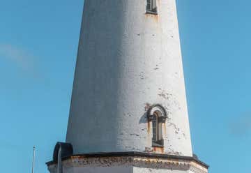
Tours meet at the former Piedras Blancas Motel 1.5 miles North of the light station, Cambria, CA, US

Piedras Blancas Light Station

11
12
12mi 00h 18m

6550 Moonstone Beach Dr, Cambria, CA, US

Moonstone Beach Bar & Grill

12
13
12mi 00h 15m
Photo of Estero Bluffs State Park
4.0

750 Hearst Castle Road, San Simeon, CA, US

Estero Bluffs State Park

13
14
13mi 00h 15m
Photo of Morro Bay State Park
4.5

Morro Bay State Park Rd., Morro Bay, CA, US

Morro Bay State Park

14
15
201mi 03h 22m
276mi 04h 08m