Today, the New Mexico section of Route 66 clocks in at just over 250 miles of remaining road, but that wasn't always the case. The original alignment, mapped out in 1926, covered more than 500 miles through the Land of Enchantment and included an S-shaped detour in the middle of the state. When the New Mexico portion of the route was redrawn in 1937, more than 100 miles were knocked off.
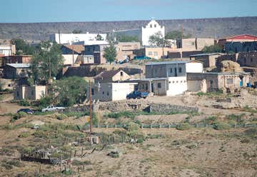
The Laguna Pueblo is located 45 minutes west of Albuquerque, right on Route 66. When you pass the whitewashed St. Joseph church, you’ll know that you’ve arrived at the pueblo, which spans four counties and comprises six villages. Part of the pueblo dates back to the 1400s, but people have been settled in the area since at least the 1300s, and tribes have passed through since 3000 B.C. The Pueblo of Laguna is especially fun to visit during feast days: March 19, July 25 to 26, August 10, August 15, September 8, September 19, September 25, and October 17.

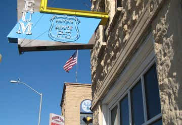
There should always be room in your itinerary for one more mining museum. At the New Mexico Mining Museum in Grants, you’ll learn all about the “carrot capital” of the U.S. Grants, which began as a logging town, suffered during the 1930s as the industry declined. The town took advantage of its volcanic soils, which were quite fertile, and turned to agriculture to revitalize the local economy. But it was the discovery of uranium near Haystack Mesa by a Navajo shepherd that really created a boom in Grants. The mining boom lasted until the late 1980s, when the town once again sunk into an economic depression. Today, Grants sees a steady stream of tourists and it’s a great place to stop for vintage motels and neon sign photo ops.
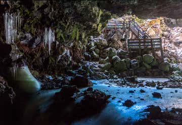
The Ice Cave and Bandera Volcano south of Grants is a privately owned and operated cave, absolutely worth its $6 to $12 entrance fee. There’s a half-mile walk to the volcano, and a 400-yard walk to the Ice Cave, which, thanks to its low temperatures, creates green ice formations that are around 20 feet thick. Be sure to wear good shoes, because the trail is lined with tiny pebbles and can be difficult to traverse without good traction. If you visit in the hot summer months, this stop can be a cool and refreshing break from the road.
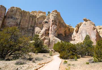
At El Morro National Monument you can read messages that ancient Puebloan, Spanish, and American travelers carved into the sandstone over hundreds of years. The messages, dates, signatures, and petroglyphs are a living time capsule. Plan to stop for a minimum of 30 minutes to see the base of the monument with the inscriptions. If you have extra time, take a 2-mile round trip hike to the top of the monument and check out what remains of the ancestral Puebloan dwellings. Note that the trail is closed periodically throughout the day, so it is best to arrive at least a few hours before closing.

The Wow Diner will make you feel as if you’ve time-traveled back to the 1950s. This is a popular spot, so prepare for a wait. Order one of the homemade milkshakes made with real ice cream or a glass of wine or beer—something you don’t always find at these retro diners.
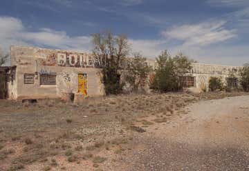
Bowlin’s Old Crater Trading post, named after the volcanic crater nearby, was built in 1954 by Claude Bowlin, replacing an earlier post at the same location that was built in 1936. Bowlin’s closed in 1973 after I-40 bypassed the town, but it’s since been added to the National Register of Historic Places. The trading post is permanently closed—and the interior isn’t accessible—but it’s a great photo op.

Gallup is the largest city between Albuquerque and Flagstaff, Arizona, along Route 66, and it’s full of motels, dining options, and classic neon signage. Don’t miss the Muffler Man cowboy located just off the route near downtown. If you’re staying overnight, you can’t get much better than the old Hollywood El Rancho Hotel and Motel. Gallup, which lies in the middle of a Navajo Reservation, is also home to an abundance of Native American crafts, artwork, and history.

The historic El Rancho Hotel in Gallup was built by Joe Massaglia in 1936 and has been featured in dozens of old Hollywood movies. The Western-style hotel is listed on the National Register of Historic Places and features wagon-wheel headboards and suites named after famous Hollywood Western stars. Even if you don't spend the night here, at least pull over to check out the epic hunting lodge-inspired lobby, which is full of antiques and Native American decor. The onsite restaurant makes a delicious green chile enchilada, a tasty margarita, and the crispiest pancakes you’ll find along the route.
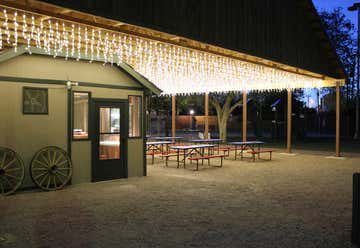
One reason Route 66 became so popular is because it crosses some of the country’s most unique landscapes. The USA RV Park, located just off the historic route, is a great place to soak up some of those old-school road trip vibes. With a nightly cookout (May through October only), a multitude of activities, and well-kept facilities, this spot is a great reminder of why road trips are so much fun.

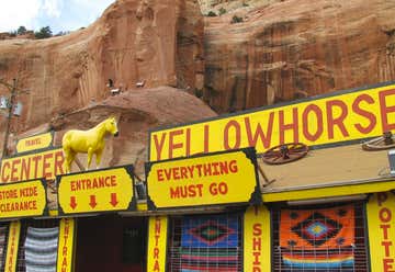
Once you cross the border into Arizona, Yellowhorse Trading Post, conveniently located on I-40 in Lupton (and next to the Teepee Trading Post), should be your first stop. This Navajo-owned trading post has been run by the Yellowhorse family since the 1950s, when they began selling Navajo rugs and petrified wood to travelers.
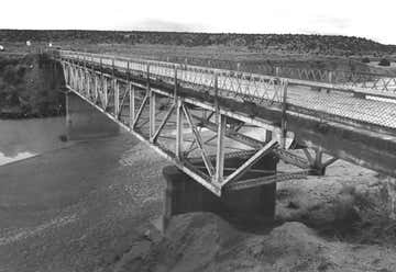
The Allentown Bridge, located in Apache County, is a great photo op. Built in 1923, the bridge crosses the Puerco River and is on the National Register of Historic Places. While you’re in the neighborhood, the Querino Canyon Bridge on old Route 66, just a few miles away, is another stunner.
A forest in the middle of Arizona’s grassland may sound odd, but Petrified Forest National Park is unlike any other forest in the country. The park is packed with gems—quite literally, since the ancient wood has been turned into sparkly stone—that anyone, from the outdoor enthusiast to the science geek, can enjoy.
The park’s location right off the highway means that many people at least drive through it (though it closes as early as 5 p.m., so plan accordingly). A portion of old Route 66 is located within the park—the only portion of the classic road to still be preserved within a national park (the asphalt is gone so it’s not driveable, but look for the old telephone poles marking the route). Wilderness camping is available within the park. Homolovi State Park, about an hour away, also offers camping options. Nearby in Holbrook, Arizona, are additional accommodation and camping options, including a KOA.
Don't let the glittering logs temp you into snagging a souvenir—removing any petrified wood from the park is illegal. You can purchase a box of petrified wood from a gift store (sourced from private lands), but don’t open it until you’ve left the park premises.
Summers in the park can get hot, with little to offer in the way of shade, and winters are often cold and snowy. Wildflowers pop up throughout the desert between March and October, especially in May, July, and August, so if you're looking for an extra colorful landscape, this is a good time to visit.
The Painted Desert Visitor Center is a good first stop on your tour of the park. It has an educational film, a gift shop, and plenty of petrified wood for sale.

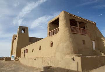
The national park is home to the famous Painted Desert Inn, and even though you can't spend the night here anymore, you should definitely stop in to check out the exhibits (the Inn was originally constructed of petrified wood, until a makeover in the 1930s). Don’t miss the displays of artwork from the park's resident artist program.
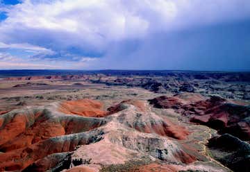
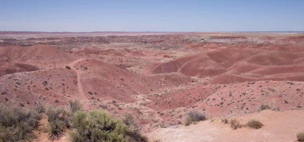
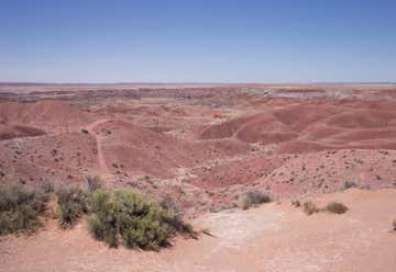
For the best views—and to see how the Painted Desert got its name—head to Kachina Point. Bands of different colored sediment in the rolling hills make for a perfect photo op.
There’s only one more section of the Mother Road left to complete—and while we don’t want to play favorites and say we saved the best for last, there are still plenty of roadside gems left to see. This is the home stretch, so slow down, take that detour, and savor every last bit of this epic Route 66 journey before you hit the “End” sign on Santa Monica Pier.
Banner Photo Credit: Roadtrippers
