Karen, Susan, Robert and I will be making a wonderful two-week road trip throughout the west. Starting in Las Vegas with major stops at Yosemite National Park, Grand Teton National Park, Yellowstone National Park, Custer Battlefield, and Mount Rushmore National Monument among many other sites.

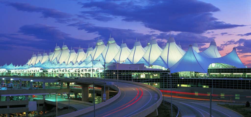
This is the start of our two week western trip from Las Vegas to Denver. McCarran International Airport is the principal commercial airport serving Las Vegas and Clark County, Nevada, United States. The airport is five miles (8 km) south of downtown Las Vegas, in the unincorporated area of Paradise in Clark County. It covers 2,800 acres (1,100 ha) and has four runways.
3200 Las Vegas Boulevard North, Las Vegas, Nevada, United States
Go to Dick's Sporting Goods to pick up some trip supplies from our list. Should not take long.
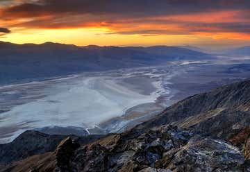
On the drive on Tue Sept 14 - Dante's View is a viewpoint terrace at 1,669 m (5,475 feet) height, on the north side of Coffin Peak, along the crest of the Black Mountains, overlooking Death Valley. Dante's View is about 25 km (15 miles) south of Furnace Creek in Death Valley National Park. Stare down nearly 6,000 feet onto Badwater, Death Valley's lowest point.
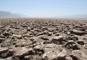
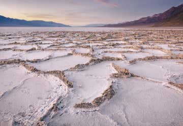
On the drive on Tue Sept 14 - The Devil's Golf Course is a large salt pan on the floor of Death Valley, located in the Mojave Desert within Death Valley National Park. The park is in eastern California. It was named after a line in the 1934 National Park Service guide book to Death Valley National Monument, which stated that "Only the devil could play golf" on its surface, due to a rough texture from the large halite salt crystal formations. Crystallized minerals reacting with groundwater have lifted themselves into tightly packed ridges and globules up to 2 feet high. Most of the ridges will support your weight if you want to walk them.
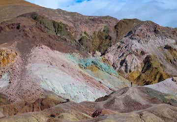
On the drive on Tue Sept 14 - Artist's Drive rises up to the top of an alluvial fan fed by a deep canyon cut into the Black Mountains. Artist's Palette is on the face of the Black Mountains and is noted for having various colors of rock. These colors are caused by the oxidation of different metals (red, pink and yellow is from iron salts, green is from decomposing tuff-derived mica, and manganese produces the purple). Called the Artist Drive Formation, the rock unit provides evidence for one of the Death Valley area's most violently explosive volcanic periods. The Miocene-aged formation is made up of cemented gravel, playa deposits, and much volcanic debris, perhaps 5,000 feet (1500 m) thick. Chemical weathering and hydrothermal alteration are also responsible for the variety of colors displayed in the Artist Drive Formation and nearby exposures of the Furnace Creek Formation. This is the lowest place in North America — a required stop for first time visitors to Death Valley. Approximately 60 minutes allocated to see the above sight. Park at the second dip (it'll be obvious) a walk aways up an unnamed, unsigned canyon for views of various color shades of rock.
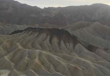
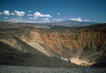
On the drive on Tue Sept 14 - Zabriskie Point is a part of Amargosa Range located in east of Death Valley in Death Valley National Park in the United States noted for its erosional landscape. It is composed of sediments from Furnace Creek Lake, which dried up 5 million years ago—long before Death Valley came into existence. Millions of years prior to the actual sinking and widening of Death Valley and the existence of Lake Manly, another lake covered a large portion of Death Valley including the area around Zabriskie Point. This ancient lake began forming approximately nine million years ago. During several million years of the lake's existence, sediments were collecting at the bottom in the form of saline muds, gravels from nearby mountains, and ashfalls from the then-active Black Mountain volcanic field. These sediments combined to form what we today call the Furnace Creek Formation. The climate along Furnace Creek Lake was dry, but not nearly as dry as in the present. Camels, mastodons, horses, carnivores, and birds left tracks in the lakeshore muds, along with fossilized grass and reeds. Borates, which made up a large portion of Death Valley's historical past were concentrated in the lakebeds from hot spring waters and alteration of rhyolite in the nearby volcanic field. Weathering and alteration by thermal waters are also responsible for the variety of colors represented there. Regional mountains building to the west influenced the climate to become more and more arid, causing the lake to dry up, and creating a dry lake. Subsequent widening and sinking of Death Valley and the additional uplift of today's Black Mountains tilted the area. This provided the necessary relief to accomplish the erosion that produced the badlands we see today. The dark-colored material capping the badland ridges is lava from eruptions that occurred three to five million years ago. This hard lava cap has retarded erosion in many places and possibly explains why Manly Beacon, the high outcrop to the right, is much higher than other portion of the badlands. Manly Beacon was named in honor of William L. Manly, who along with John Rogers, guided members of the ill-fated Forty-niners out of Death Valley during the gold rush of 1849.
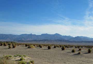
About 2 hours to pass through this park on the drive on Tue Sept 14. The hottest, driest, and lowest national park in the U.S. features sand dunes, colorful mudstone cliffs, salt flats, spiky salt mounds, ghost towns, canyons, lush oases, historic displays, and probably a million other things. The climate here is harsh. Death Valley is the largest U.S. National Park outside Alaska at 3.4 million acres. Nearly 1000 miles of paved and dirt roads provide access to locations both popular and remote. Even so, 91% of the park is protected as officially designated Wilderness. That wild country includes low valley floors crusted with barren salt flats, rugged mountains rising as much as 11,000 feet, deep and winding canyons, rolling sand dunes, and spring-fed oases. Despite the harshness and severity of the environment, more than 1000 kinds of plants live within the park. Those on the valley floor have adapted to a desert life by a variety of means. Some have roots that go down 10 times the height of a person. Some plants have a root system that lies just below the surface but extends out in all directions. Others have leaves and stems that allow very little evaporation and loss of life giving water.
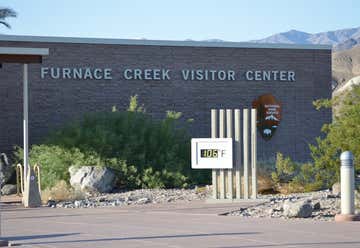
Pass through this National Park on the drive on Tue Sept 14. The Furnace Creek Visitor Center is the main visitor information source for the park. There is a fully staffed information desk with information on all aspects of the park and its operation. The Death Valley Natural History Association maintains a well stocked book sales outlet specifically geared towards the natural and cultural history of the park. Approximately 40 minutes allocated to see the above sight.
Pass through this National Park on the drive on Tue Sept 14. The Devil's Cornfield is located along Highway 190 between Stovepipe Wells and Beatty Junction (just east of the sand dunes). The plant that gives the area its unique appearance is an evergreen plant, arrowweed (Pluchea sericea) (USDA, [2010]). As the common name implies, the plant's woody stocks were used by American Indians to make arrows. Approximately 10 minutes allocated to see the above sight.
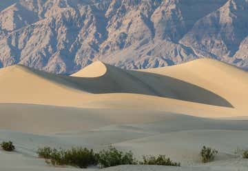
Drive through on Tue Sept 14. These dunes are the best known and easiest to visit in the national park. Located in central Death Valley near Stovepipe Wells, access is from Hwy. 190 or from the unpaved Sand Dunes Road. Although the highest dune rises only about 100 feet, the dunes actually cover a vast area. This dune field includes three types of dunes: crescent, linear, and star shaped. Polygon-cracked clay of an ancient lakebed forms the floor. Mesquite trees have created large hummocks that provide stable habitats for wildlife. The Mesquite Flat Sand Dunes are at the northern end of the valley floor and are nearly surrounded by mountains on all sides. Due to their easy access from the road and the overall proximity of Death Valley to Hollywood, these dunes have been used to film sand dune scenes for several movies including films in the Star Wars series. The largest dune is called Star Dune and is relatively stable and stationary because it is at a point where the various winds that shape the dunes converge. The depth of the sand at its crest is 130–140 feet (40–43 m) but this is small compared to other dunes in the area that have sand depths of up to 600–700 feet (180–210 m) deep. The primary source of the dune sands is probably the Cottonwood Mountains which lie to the north and northwest. The tiny grains of quartz and feldspar that form the sinuous sculptures that make up this dune field began as much larger pieces of solid rock. In between many of the dunes are stands of creosote bush and some mesquite on the sand and on dried mud, which used to cover this part of the valley before the dunes intruded (mesquite was the dominant plant here before the sand dunes but creosote does much better in the sand dune conditions). Approximately 20 minutes allocated to see the above sight.
Drive through on Tue Sept 14. Mosaic Canyon is a showcase of geologic features as well as a beautiful example of one of Death Valley’s many canyons. Located 1/4 mile west of Stovepipe Wells Village, the 2 mile gravel access road climbs 1000 ft. to the parking area. From here an easy 1/4 mile walk leads into the canyon narrows, where the surrounding rock walls are composed of smooth, water-polished marble. Approximately 2h 30 minutes allocated to see the above sight.

King room. Portal Motel provides air-conditioned accommodations in Lone Pine. All rooms have a flat-screen TV with satellite channels and a private bathroom. The property has a 24-hour front desk and free WiFi throughout the property. All rooms will provide guests with a microwave. FREE cancellation before 11:59 PM on September 17, 2021. NO PREPAYMENT NEEDED – pay at the property. Through Booking.com total price $221.76 or $110.88 per couple.
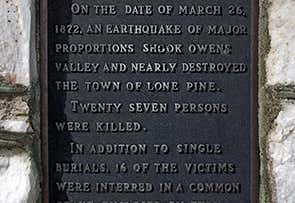
Drive by on Wed Sept 15. GRAVE OF 1872 EARTHQUAKE VICTIMS- On March 26, 1872, a major earthquake shook Owens Valley, nearly destroying the town of Lone Pine. About fourteen of its victims (the exact number is not known) were interred in a common grave, enclosed by this fence. Approximately 5 minutes allocated to see the above sight.
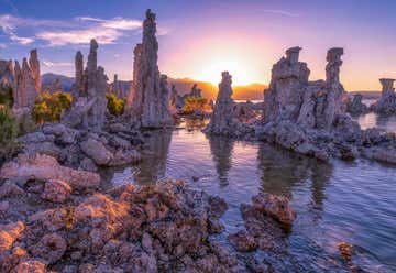
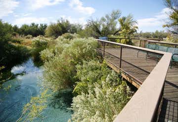
The unusual rock formations that grace Mono Lake’s shores are known as tufa. Tufa towers are beautiful, and they are also important habitat, from nesting sites for Osprey and owls to underwater habitat for alkali flies. Tufa forms in a variety of ways at Mono Lake, but the most visible and remarkable formations are the towers that stand tall along Mono’s shoreline.The Mono Lake tufas have been fascinating visitors to the Eastern Sierra of California for many years. A part of Mono Lake Tufa State Natural Reserve, the Mono Lake tufa towers are not only beautiful to view and photograph, they are also a habitat for birds and wildlife. Mono Lake is an old lake: over a million years old! Covering almost 70 square miles, the saltwater lake lies between the majestic Sierra Nevada mountains and the dry Great Basin, in eastern California. The Mono Lake South Tufa loop trail, which starts at the South Tufa information kiosk, is flat and super easy, about one mile in length. It is only accessible for the first quarter mile. It should take about one hour, with a few stops for photos. Wear water shoes if you want to step into the water. Approximately 60 minutes allocated to see the above sight.

The Tioga Road (Highway 120) climbs above the Valley, transporting you to breathtaking views and pristine lakes. It cuts through the mountains at Tioga Pass. In the spring and summer months, winter melts away and the meadows bloom. The waters of Tenaya Lake and the Tuolumne River soak up the heat of the sun, inviting you to swim, fish, and hike along their banks. Spot flowering purple lupine and bright yellow monkey’s paw and slide otter-like through river rapids in Tuolumne Meadows. Lay out on sun-warmed granite slabs, or get your heart rate up scaling Lembert Dome. On your way up the Tioga Road, pull over at the Olmsted Point overlook to see the Valley laid out beneath your feet.
State Route 120 runs through it, and serves as the eastern entry point for Yosemite National Park, at the Tioga Pass Entrance Station. It is the highest highway pass in California and in the Sierra Nevada. Mount Dana is to the east of the pass. Approximately 15 minutes allocated to see the above sight.
Tuolumne Meadows (/tuˈɒləmi/) is a gentle, dome-studded, sub-alpine meadow area along the Tuolumne River in the eastern section of Yosemite National Park in the United States. One of the largest high-elevation meadows in the Sierra Nevada, Tuolumne Meadows at 8,600 feet has been also among the most visible to past pioneers, and present visitors and scientists. It’s accessible due to the park roadway that crosses the southern edge of the meadow. From this point all the way to the south of Mt. Whitney, no other roads cross the High Sierra. Thus, this roadway marks the northern end of the largest contiguous roadless wilderness in the continental United States. Within Tuolumne Meadows, visitors see the Tuolumne River meandering quietly through its meadow channel and cascading over the granite river bottom against a backdrop of rugged mountain peaks and glacially carved domes. The river, declared by Congress a Wild and Scenic River in 1984, originates in the high country near the east side of the park.
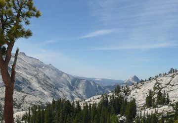
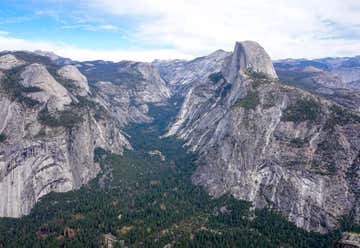
Olmsted Point is a famous vista of the northern side of Half Dome, Tenaya Canyon and Tenaya Lake to the east from Tioga Pass off State Highway 120 in Mariposa County. Olmsted Point is a must-do stopping point as you venture over Tioga Pass. Wander around the so-called “erratic” boulders that are staggered around the granite slopes. These giant boulders were left when the last glacier came through. Olmsted Point is named for a landscape architects Frederick Law Olmsted and Frederick Law Olmsted, Jr. Olmsted was instrumental in the protection of Yosemite in 1860s, as he worked with Senator John Conness of California to designate Yosemite Valley and Mariposa Big Tree Grove as public lands under the protection of the State. This was the first land set aside by Congress for public use and laid the foundation for what would later become the National Parks.
Spend two and 1/2 days at Yosemite on Wed Sept 15 through Fri Sept 17 with lodging at the Wawona Hotel in the park.
Best Ways to Spot Wildlife in Yosemite is to visit with an experienced naturalist guide who knows the park well. Tour guides can share the best places to see animals, as well as information about the various species. Head to meadows such as Mariposa Grove and Tuolumne, which are rich habitats where animals are more likely to be seen. At higher elevations, groves of the famous giant sequoias offer bountiful biodiversity. Check in with a National Park Service ranger; they have the latest information and tips for wildlife viewing. What We Can See: Black bears, mule deer, bobcats, mountain lions, foxes, and bighorn sheep are some of the most commonly spotted mammals at Yosemite National Park. There are also more than 250 species of birds, plus a variety of amphibians and reptiles, including three species that can only be found in the Sierra Nevada mountain range. Keep an eye out for turtles, snakes, and the Yosemite toad.
Banner Photo Credit: shawntrice
