
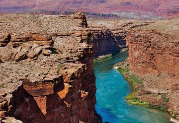
“one of only 7 land crossings over the Colorado River” Those traveling across the country on Highway 89A between Bitter Springs and Jacob Lake AZ arrive at two bridges similar in appearance spanning the Colorado River. These two bridges, one historic and one new, represent one of only seven land crossings of the Colorado River for 750 miles (1207 km). In the 1870’s, pioneers from Utah began to expand their settlements into northern Arizona. Nearly 600 miles (965 km) of deep canyons along the Colorado River stood in their way. One of the only places a wagon could reach the river from both north and south was at the mouth of Glen Canyon. Since the area was accessible and was a natural corridor between Utah and Arizona, a ferry was established there in 1873. Named after the first ferry operator, John D. Lee, Lees Ferry became an important route for pioneers, settlers and local traffic. In the 1920’s, automobiles began using the ferry as a means to cross the Colorado River. It was recognized that it was time to find a safer, more reliable way for vehicles to cross. A bridge site was selected 5 miles (8km) downriver at Marble Canyon. Construction of the bridge began in June of 1927. This was rugged and remote country and it was difficult to get men, materials and equipment from one rim to the other, a distance of only 800 feet (244m). The ferry was used to transport materials when possible. However, on June 7, 1928, the ferry sank in an accident which killed three men. Since the bridge known then as Grand Canyon Bridge was nearing completion, the ferry was not replaced. So, for the next several months, no direct route existed between Utah and Arizona. People had to travel 800 miles (1287km) around the canyon to reach the other side of the river. It was an historic day when, on January 12, 1929, the bridge was opened to traffic. At the time, it was the highest steel arch bridge in the world and made traveling between Utah and Arizona much easier. No longer did travelers have to contend with the moods of the Colorado River at Lees Ferry. The dedication of the bridge took place June 14-15, 1929. For such an isolated spot, it was an astounding event. Nearly 7,000 people in 1,217 automobiles arrived for the celebration. Speeches were given by the governors of Arizona, New Mexico, and Utah and by the President of the Mormon Church. Bands, choral groups, and Native American dancers were also a part of the festivities. It was reported that airplanes flew under the bridge and as Prohibition was in effect, the bridge was christened with a bottle of ginger ale. The bridge was known as the Grand Canyon Bridge for five years following the dedication. In 1934, after great debate in the Arizona legislature, the official name was changed to Navajo Bridge.
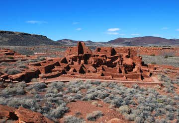
“experience a legacy!” Nestled between the Painted Desert and ponderosa highlands of northern Arizona, Wupatki is a landscape of legacies. Ancient pueblos dot red-rock outcroppings across miles of prairie. Where food and water seem impossible to find, people built pueblos, raised families, farmed, traded, and thrived. Today, if you linger and listen, earth and artifacts whisper their stories to us still.
Wupatki National Monument preserves dozens of ancestral Puebloan villages. Though silence reigns today, this place was once a bustling hub of trade and life. People of the Northern Sinagua, Cohonina, Kayenta, and Hohokam archeological culture groups planted corns, beans, squash, and cotton among these seemingly barren hills and washes. Where many now see only dirt and hear only wind, ancient Native American people lived, raised children, and thrived. Wupatki is not as silent as it seems. Walls can talk, and if you linger long enough to listen, these teach many lessons.

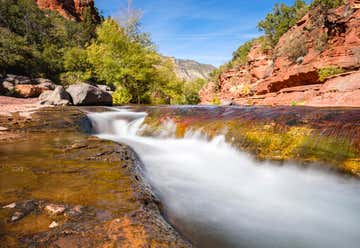
“all natural waterslide!” Slide Rock State Park, originally the Pendley Homestead, is a 43-acre historic apple farm located in Oak Creek Canyon. Frank L. Pendley, having arrived in the canyon in 1907, formally acquired the land under the Homestead Act in 1910. Due to his pioneering innovation, he succeeded where others failed by establishing a unique irrigation system still in use by the park today. This allowed Pendley to plant his first apple orchard in 1912, beginning the pattern of agricultural development that has dominated the site since that time. Pendley also grew garden produce and kept some livestock. As one of the few homesteads left intact in the canyon today, Slide Rock State Park is a fine example of early agricultural development in Central Arizona. The site was also instrumental to the development of the tourism industry in Oak Creek Canyon. The completion of the canyon road in 1914 and the paving of the roadway in 1938 were strong influences in encouraging recreational use of the canyon. Hence, Pendley followed suit and in 1933, built rustic cabins to cater to vacationers and sightseers. Todays visitors can still enjoy the fruits of Pendley's labor. Historic cabins are available for viewing, and the creek offers the park's namesake slide for adventures seekers and those looking for a place to cool off.
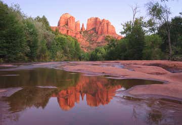
“symbol of the American Southwest” Red Rock Crossing is a symbol of the American Southwest and the most photographed spot in Arizona. It is a favorite place for artists and art classes to visit and paint. It has been featured in more than 60 classic Hollywood films and is displayed on hundreds of postcards, posters, calendars and billboards. Red Rock Crossing is one of the best places to view Sedona’s beautiful red rocks. It is also the location where photographers go to get the iconic photos of the red rocks with the stream in the photo.
Red Rock Crossing State Park is one of my families favorite hikes, and is the perfect day stop for a hike before or after lunch. You can do it in a couple of hours, and still see other parts of Sedona.
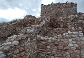
Crowning a desert hilltop is an ancient pueblo. A child scans the desert landscape for the arrival of traders. What riches will they bring? What stories will they tell? From the rooftop of the Tuzigoot pueblo it is easy to imagine such a moment. The pueblo shows us this ancient village built by the Sinagua people. They were farmers and artists with trade connections that spanned hundreds of miles.

“Would Your House Look This Good 800 Years From Now?” Montezuma Castle National Monument one of the best preserved cliff dwellings in North America. This 20 room high-rise apartment, nestled into a towering limestone cliff, tells a story of ingenuity, survival and ultimately, prosperity in an unforgiving desert landscape. Visitors can marvel at this enduring legacy of the Sinagua culture and reveal a people surprisingly similar to ourselves. Approximately 350,000 people a year gaze through the the windows of the past during a visit to Montezuma Castle. Even 600 years after their departure, the legacy of the Sinagua people continues to inspire the imaginations of this and future generations.
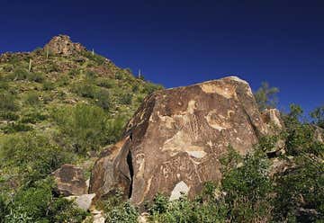
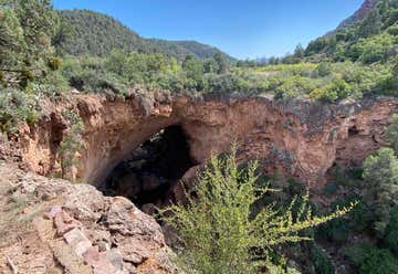
“Sports in Pine, AZ” This 2-mile trail in White Tank Mountain Regional Park is good for all skill levels. In addition to ancient petroglyphs, hikers will see a variety of cacti and, of course, a waterfall (assuming it’s flowing). Waterfall Trail is barrier-free for 5/10 of a mile. The handicap accessible portion now ends about 1/10 of a mile past Petroglyph Plaza.
See handout
9573 North 82nd Glen, Peoria, Arizona, United States
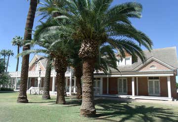
Sahuaro Ranch was founded in 1886, by William Henry Bartlett, a native of Illinois. The ranch, located north of what eventually became the city of Glendale, Arizona, was rich in figs and other fruit orchards, vineyards, and fields of alfalfa. The ranch has all of its historical structures restored, and the "Sahuaro Ranch Park" is administered by the Parks and Recreation Department of Glendale. On March 7, 1980 Sahuaro Ranch was listed in the National Register of Historical Places. (See handout)
40816 Eliana Drive, San Tan Valley, Arizona, United States
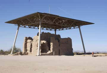
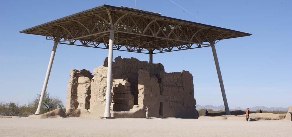
Casa Grande Ruins National Monument contains an imposing 4-storey building dating from the late Hohokam period, probably 14th century and contemporary with other well preserved ruins in Arizona such as the Tonto and Montezuma Castle monuments. It is situated in the flat plain of central Arizona in between the Gila and Santa Cruz rivers, just north of Coolidge and about 15 miles from the larger town of Casa Grande.
The structure was once part of a collection of settlements scattered along the Gila River and linked by a network of irrigation canals.
