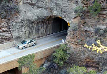
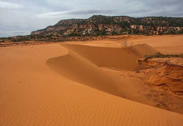
A friend and I took this trip a few years ago, and it was still at one of my favorite roadtrips! Aside from the national parks, there are so many other great stops along the way, be sure to give yourself enough time to take a good look around!

This hike is permitted / ticketed only, be sure to get them beforehand!
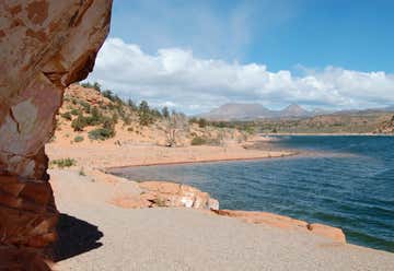
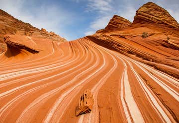
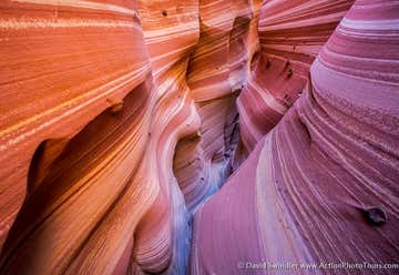
The majority of the canyons, cliffs, and towers of Zion were sculpted by the Virgin River in mostly Jurassic age strata- Navajo Sandstone, Kayenta Formation, and Moenave Formation. The canyon floors are mostly made up of the Triassic Chinle Formation and Moenkopi Formation. These sedimentary rocks tell a 270 million year old story of an ancient desert landscape where mud, silt, and wind-blown sand accumulated in large quantities. In fact, Zion has some of the finest "fossilized" wind-deposited sand dunes in the world!
The Navajo Sandstone is the main rock layer. It was deposited in an ancient sandy desert, much like the Sahara Desert. This deposits maximum thickness is about 2200 ft (671 m)! During deposition, this area was covered by large dunes that were most likely as high as 150 ft or more! Quartz sand grains moved up the dune until they reached the crest, then would fall down the steep other side of the dune and create crossbedding. From the crossbedding, you can even figure out which direction the winds were blowing during the time of the time of the dinosaurs, which is super cool!
The Navajo might be the thickest layer in the park, but the Kayenta Formation plays a huge roll in the width of Zion Canyon. At the end of the park road at river level, a recent rockslide of Navajo Sandstone occurred where the Kayenta undermined it. Just past this, the Kayenta is no longer on the surface and the river is just eroding the Navajo. This creates a much thinner canyon, known as the "Narrows" hike. The Narrows is both an adventure and a geology lesson. At its tightest point, the canyon is only 16 ft wide and 1000 ft deep. If you want to get really up close and personal with the Navajo Sandstone, that is one way to do it!
One of the amazing things about Zion is all of the colors. Greens, pinks, reds, and whites all swirl together to make up this beautiful area. We have geology to thank for that too! The Navajo Sandstone has a small amount of iron-bearing minerals in its grains. This turns the rock a reddish color. However, the upper part of the Navajo is white. This is probably caused by acidic groundwater seeping through the rock, which "bleached" the rock by dissolving the iron. The pink colored rock could represent the transition zone beneath the groundwater zone and the bottom zone. There is also areas with black streaks, called "Desert Varnish", which result from precipitation of iron and manganese as groundwater and rain evaporate from the rock face.
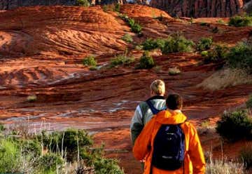
What geologic features should you look for in Zion NP? You can't miss the amazing colors, but be sure to try and distinguish the different formations in the canyon walls. Get up close and personal with the rock by hiking and check out the preserved crossbedding of ancient sand dunes. Get your compass out and see if you can figure out what way the wind was blowing! Find the different "weeping" rocks, and get up high in the canyon to spot ancient land slides and rock falls!

"Photos from Zion NP!" — Photo Credit: Jess Scanlan

First things first- Bryce is not really a "canyon" at all, but a series of large amphitheaters cut into the Pink Cliffs. The rock exposed is Jurassic to Neogene, and the hoodoos are formed from the Claron Formation (more about that in a sec!).
Bryce was formed in a similar sandy desert to Zion, and the Navajo Sandstone is under the rocks seen in the park. As time passed, the sea level began to rise, creating the Western Cretaceous Interior Seaway. BCNP was situated along the margins of this seaway and recorded the climatic and tectonic changes in its rock record. The Dakota Formation was deposited in nearshore environments, then as the sea level rose to its maximum depth the Tropic Shale was deposited. This preserved many marine fossils, such as burrows from ants, wasps, and crayfish. With continued sea fluctuations and the final withdrawal, the Straight Cliffs, Wahweap, and Kaiparowits formations were deposited. Much later, the Claron Formation was deposited. The lower part of the Claron (the Pink Member) represents deposits occurring on a broad plain including stream channel sandstones, siltstones, and pebble conglomerates. The upper part (White Member) was deposited in broad lakes. Bed-by-bed rock variations helped to create the famous hoodoos.
Speaking of hoodoos, what are they? A hoodoo is basically a giant rock column, it almost reminds me of a stalagmite! They're unique and rare, and formed by many complicated geologic processes. First, plate tectonic forces induces stresses on the rock strata. These events include the late stages of the Laramide Orogeny, the uplift of the Colorado Plateau, and present-day Basin and Range extension. These stresses produced fracture systems, the two main ones intersect to create a cross-hatched pattern of weakened rock. Then, as the Claron was exposed, physical and chemical weathering processes disaggregate the rock along the fracture sets. Freeze-thaw cycles play a big roll in forming the hoodoos. As the weathering processes continue, deep "slot" canyons and rock walls are produced. As fractures through the rock erode, forming columns and pinnacles. The many rock layers erode differently, creating curved recesses and bulging knobs. Many times you can see fun shapes created in the hoodoos, such as Queen Victoria on the Queens Trail hike! All the processes to form the hoodoos had to happen or else there would be no hoodoos, and this mace BCNP very unique and rare.
Bryce Canyon is a stunning view of pinks, oranges, and whites. These colors mostly come from the oxidation state and amount of iron in the rocks. Iron-bearing minerals and rock fragments that were deposited in oxygen-rich nearshore environments were oxidized into their ferric state, giving rocks their orange color. Sediment deposited in oxygen-poor environments retains its ferrous state and displays green, gray, or black colors (like the Tropic Shale).
You don't have to look hard for amazing geology in Bryce Canyon, any of the viewpoints will do! Get up close to some hoodoos, and see why they call it "Inspiration Point"! Identify the different joints that create the hoodoos and see the lines of the geologic layers.

"Photos from Bryce Canyon NP!" — Photo Credit: Jess Scanlan
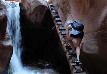
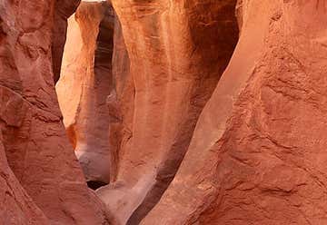
This is such a cool slot canyon! We didn't do our research beforehand and didn't make it all the way through, but it was a fun time anyway! Be sure to take enough water, there isn't a lot of shade on the way.

The main purpose of the national park was to preserve the landscape surrounding the Waterpocket Fold. The Waterpocket Fold is a 90-mile monoclinal flexure of the Earth's crust. Colorful sedimentary rocks ranging from the Permian Period to the Cretaceous Period make up the beautiful scenery of this area.
A monocline is a fold in the Earth's crust, where one flank of the fold is steeply inclined and the other is nearly flat. The Waterpocket Fold began forming between 70 and 50 million years ago, in response to North America's westward movement over the Pacific Ocean Plate. Tectonic stresses resulted in faulting and folding of the area, and Precambrian rocks were shoved upward approximately 7000 ft. This caused the overlying layers to passively drape irregularly over the area.
So what's the big deal with the Waterpocket Fold? When sandstones are exposed for long periods of time, rainwater dissolves the cement between sand grains. This process proceeds more rapidly where cement rims are composed of calcium carbonate. Where dissolution occurs, the sand grains are loosened and blown away by the wind. Rainwater becomes concentrated in depressions, creating waterpockets. These water pockets are created differently than tanks and potholes, making them unique. In this hot, barren desert, these water pockets are often the only source of water between storms.
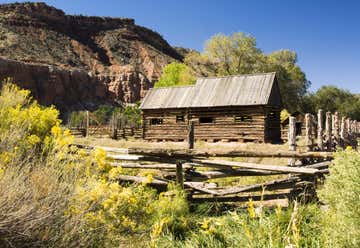
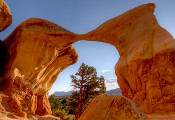
There is a ton of cool geology to see in Capitol Reef. Right next to the visitor center is the stunning "Castle", that is worth taking a long look at! The scenic drive runs along the rim of the dipping strata making for stunning views. And make sure to keep an eye out for some of the famous waterpockets!

"Capitol Reef NP!" — Photo Credit: Jess Scanlan
Banner Photo Credit: Jessica Scanlan

Jess
I'm a geologist and adventure lover living in the gorgeous state of Montana! Follow along here for great Montana routes, or check out the routes for the #MiningRoadTrip! Feel free to download/print the itineraries, and send me pics when you go on the trips!!