This trip is brought to you by our friends at 76®!
Deep in the heart of the Sierra Nevada, just outside the Yosemite Valley, lies one of California's most intriguing landscapes. Strange and varied formations shaped by volcanic forces can be found all along the 76-mile route from Mammoth Lakes to Mono and out to Buckeye Hot Springs. You'll see the twisting basalt columns of Devils Postpile and craters and canyons carved by blasts. Remember to pack a bathing suit for the trip, as you won't want to pass up the chance to swim in the buoyant water of Mono Lake or soak in the warm, mineral-rich Buckeye Hot Springs.
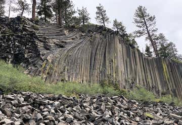
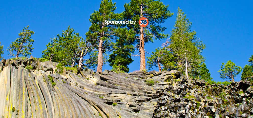
Our first stop is Devils Postpile National Monument—an amazing rock formation that got its name due to its appearance of lumber piled high, as if made by some devilish giant. Looking up at the twisting columns, it's hard to imagine how they were formed... and it's even wilder when you consider that the stone formations came from a boiling lake of red-hot lava. The slow-moving flow, which dammed up right where the monument is located, eventually cooled and contracted, forming the unusual columnar basalt pillars that we see today. To hike to the top, take the half-mile trail to the base, then continue uphill to the formation’s summit for some incredible views of the surrounding mountain ranges. There is a parking lot at Devils Postpile, but no overnight parking is allowed. The monument is typically open every year from mid-June to mid-September, but it may close early due to sudden weather changes. The park encourages travelers to check the website for unexpected closures prior to visiting.
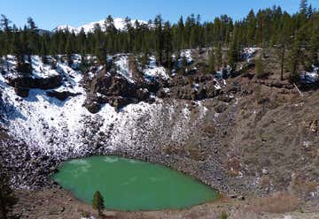
Just North of Mammoth Lakes, the next stop on our route are the Inyo Craters. These three craters were formed by a small but violent eruption that occurred about 600 years ago. Catching a glimpse of the Craters is easy enough, with the Inyo Craters Trail being conveniently located right off of Dry Creek Road. All together, the entirety of the hike is less than a mile. There are two primary trails that leave from the parking area, both of which connect at the summit. If you don't have a lot of time, then be sure to check out the two southernmost craters, which are the deepest of the bunch and contain small lakes. And if you find yourself in the area during the winter, even better! You can still access the trail by snowshoes, skis, or snowmobile.
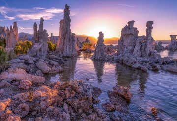
As you make your way north along Highway 395, you'll pass the beautiful (albeit slightly smelly, thanks to the sulfur) Mono Lake. Mono Lake is a majestic body of water covering about 65 square miles. Well over 1 million years old, it is one of the oldest lakes in all of North America. Hiking, photography, birdwatching, swimming, boating, and cross-country skiing are just a few of the many activities you can enjoy at this unusual lake. A swim in Mono Lake is a truly memorable experience. Like the Dead Sea, Mono Lake's salty water is denser than ocean water, providing bathers with a delightfully buoyant swim. But keep the water out of your eyes or any cuts—it will sting!
The natural history of the lake is described and explained in a one-mile self-guided nature trail at South Tufa. This is the best place to visit if you have time for only one stop. There's also a boardwalk (ADA) trail below the Mono Lake County Park, which enables access to the North Shore Tufa Area and Wetland. Or you can try the new trail, which links the Scenic Area Visitor Center near Lee Vining with the Old Marina area at the shore. Regardless of which trail you take, you're bound to see something like never before.
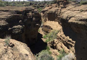
After taking a quick dip in Mono Lake, head up to Black Point Fissures for a memorable nature walk. Here you can take a short stroll or spend hours exploring the different pathways—there's something for every level of hiker. And while the area may look like nothing more than simple brown hills, upon closer inspection you'll find several deep, narrow fissures, many of which resemble small slot canyons. There is no official trail to reach the fissures, but you can easily find the best pathway by following the line of always-present footprints. The longest stretch of canyon goes on for nearly a quarter of a mile, but stays relatively flat and wide throughout. In addition to the fissures, be sure to check out the very top of Black Point, which offers grand views of Mono Lake, Mono Valley, and the Sierra Nevada Mountains.

A stop at the Mono County Museum not only offers a quiet place to stretch your legs, but a rich history of the surrounding area. If you like antiques, or fancy old collectibles, then this place is a must-stop. In this small museum you'll find photographs, artifacts, guns, and clothing from the early settlers of the Bridgeport Valley. For being such a small building, the museum contains a ton of interesting things to look at and read. Open Tuesday through Saturday, from 9 a.m. to 4 p.m., it costs $2 to get in and all proceeds go towards the Mono County Historical Society.
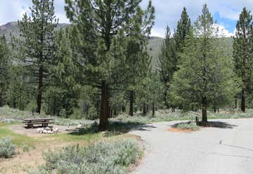
Nestled right along Buckeye Creek, sitting among the Jeffrey and Lodgepole pines, you'll find Buckeye Campground. A popular spot for backpackers and travelers heading to Yosemite, Buckeye Campground provides a quiet, peaceful space to rest and recoup. While this campground is a popular pit stop for travelers to Yosemite, it also offers plenty to do for those planning more extended visits. For instance, Buckeye Hot Springs are just east of the campground, and Buckeye creek offers unparalleled fishing. Not a fan of the water? No problem! There are plenty of hiking trails along Eagle Creek that take you right up the flanks of Eagle Mountain. The campground is usually open from late May to late September, and costs $20 per night. There are sites for both tents and RVs, but everything is on a first-come-first-serve basis.
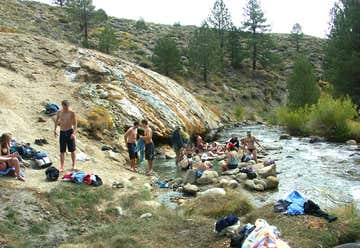
As we reach mile marker 76, our last stop on the trip is Buckeye Hot Springs. Clocking in at 104 degrees Fahrenheit, these springs are definitely hot! When you turn off Buckeye Road, be sure to park in the parking lot before heading down the dirt road (if you see any signs for the springs, you've gone too far). The hike to the springs can get a little steep and muddy, so bring proper walking shoes. Buckeye Hot Springs has become a popular place for both locals and visitors, especially in the summer months, so try to get there early and snag a good spot. But be aware of any signs or posts that section off portions of the river, as these areas have a tendency to be extra hot. And yes, your furry friend can enjoy a dip in the springs as well.
One of the most geologically diverse trips, this route through Mono County gives you the perfect mix of adventure, history, and spa-like relaxation. Taking less than two hours to drive, you can easily do the entire trip in one day. However, we think you should take your time, experience each stop, and get a real taste of all that Northern California has to offer.
