

It’s important to remember that you will be in an alpine environment, which means there is a good chance you will experience heavy rain, strong winds, snow and freezing temperatures even during the great walk season. So warm and waterproof clothing will be essential, you’ll also need a good pair of hiking boots and make sure you carry enough water for the whole trip.

The Tongariro Alpine Crossing takes you across volcanic terrain where you’ll encounter beautiful water-filled explosion craters, steaming vents and hot springs, old lava flows and stunning views. On clear days you can see Mount Taranaki in the west, Mount Ngauruhoe, the Kaimanawa Ranges, Lake Taupo and beyond.
The Crossing is one of most sought-after day walks in the world, but although beautiful, it can be dangerous if you're not fully prepared to enter an alpine environment.
Allow 7-8 hours.
Distance 19.4 km.
Extreme weather, terrain and distance have resulted in this track having the highest number of search and rescues in New Zealand, so there’s a few things you need to know before you go:
The best time is from October through to April, the days are longer, and the chances of encountering snow are much lower.
You’ll need warm and waterproof clothing, even on a nice day, a good pair of ridged hiking boots and make sure you carry enough water for the whole day as there isn’t any available along the track.
The track begins at 1120 m, climbs the Mangatepopo Valley to the saddle between Mount Tongariro and Mount Ngauruhoe, through South Crater before climbing again to Red Crater, the highest point on the crossing at 1886 m and very challenging terrain.
You will then descend on a volcanic rock scree track to the vivid Emerald Lakes, known as Ngarotopounamu (greenstone-hued lakes) but take on the lose volcanic rock. After passing Blue Lake, also known as Te Wai-whakaata-o-te-Rangihiroa (Rangihiroa’s mirror), the track sidles around the northern slope of Tongariro, then descends in a zigzag track past Ketetahi Shelter and down to the road end at 760 m.
Be prepared for a long and challenging day out.
Hikers often underestimate how long it takes to complete the hike, so starting by 8am will ensure you have plenty of daylight but pack a headtorch just in case.
Getting there:
There is a 4 hour parking restriction in place at Mangatepopo road end to allow for those doing shorter walks. However, for those hiking the entire Tongariro Alpine Crossing, licensed operators who are approved by the Department of Conservation, will not only provide timely shuttle transport but also provide expert safety knowledge on the walk and the weather plus free parking at their depot. They will also provide back-up should you suffer a mishap during the day.
Safety check:
Make sure you check the official Tongariro National park forecast at MetService.com before you go. You’re crossing volcanic apline terrain and there’s a good chance you’ll experience heavy rain, strong winds, snow and freezing temperatures even in the height of summer.
As with all walks in New Zealand make sure you leave your intentions with a trusted contact and let them know when you’ve finished. You can find out more about planning your trip at the mountain safety council website.
Winter tramping:
The winter environment at Tongariro is frequently cold, wet and windy. For your safety, it is essential to be well dressed for winter conditions. Daylight hours are short and temperatures are often below freezing. Snow and ice is common in higher areas and sometimes on the lower areas, and deep snow can hide track markers. At times surface conditions can be hard ice.
Alpine equipment and skills are required but if you don't have these, consider a guided trip with one of the guiding companies that operate in winter:
Adrift Outdoors Phone: 0800 462 374
Adventure Outdoors Phone: 0800 386 925
Tongariro Guided Walks Phone: 0800 429 255
Parts of the Tongariro Alpine Crossing passes through avalanche terrain and you’re in an active volcanic area, where eruptions are possible without any warning. Check the latest volcanic activity and avalanche risk info before you go, at the Tongariro National Park Visitor Centre and on the Geonet website. You can also check the New Zealand Avalanche Advisory (NZAA).


"Boardwalks - Tongariro Crossing" — Photo Credit: Flickr - Jeno Ortiz


"Emerald Lakes - Tongariro Crossing "


"Mount Doom - Tongariro Alpine Crossing " — Photo Credit: Flickr - Johanna Remus

Mount Taranaki is linked by legend to the mountains of the central North Island. As the story goes, Taranaki once lived with the other volcanoes of the central plateau - Tongariro, Ruapehu and Ngauruhoe. When he made flirtatious advances towards a pretty hill named Pihanga, Tongariro erupted in a jealous fury. Taranaki fled to the west, gouging out the Whanganui River on his way. Today Taranaki is still venerated and its summit is sacred to the Maori people of the area.
The grandeur of this near-perfect looking mountain has enticed many people to attempt the 2518m summit, as it takes you high above the clouds for a truly breath taking view. At lower altitudes you'll walk through tall rimu and kamahi trees; higher up the volcano, sub-alpine shrubs and herbfields are found above the snow line. Lush rainforests can be found on the mountain’s slopes and are a result of the area’s high rainfall and mild coastal climate.
However, the weather can change very fast and climbing the now dormant volcano is a serious undertaking that should not be underestimated.
This tramp is both technically and physically difficult and should only be attempted by experinced hikers with proper equipment and in good weather conditions.
6.3 km one way return via same track.
It takes 8-10 hours to complete - up 5-6 hour; down 3-4 hour.
The best time to climb Mt Taranaki is from January to mid-April when the slopes are bare of snow (though ice remains year round in the crater).
You will be in an alpine environment which means there’s a good chance you will experience heavy rain, strong winds, snow and freezing temperatures even in the height of summer. You will need warm and waterproof clothing, as well as a good pair of tramping boots.
There is no access to water on the climb so take enough to last the whole day.
This will be a very long day so make sure you leave early in the morning to ensure you have enough daylight hours to complete the tramp, and pack a headtorch just in case.
In winter and spring conditions snow and ice on the slopes requires mountaineering experience and equipment and a different route into the crater than described below. You are strongly advised not to climb in winter and spring condition unless you have appropriate experience and equipment and knowledge of Mt Taranaki.
North Egmont to Tahurangi Lodge (1,492 m).
Time: 1 hr 30 min - 2 hr.
The summit track begins above the North Egmont car park adjacent to the red Camphouse building. Walk through the small "kissing" gate and wind up the gravel road to Tahurangi Lodge (private). Sections of this track are very steep. There is a public toilet 100m below the lodge.
Tahurangi Lodge to the summit (2,518 m).
Time: 3 - 4 hr.
The track passes in front of the Tahurangi Lodge and continues upwards, via the poled route through the rock covered Hongi Valley. A series of steps leads out of the valley onto the steep scoria slopes.
Take care on these slopes as trampers above you may dislodge rocks. The scoria slope continues west of the Snow Valley to the Lizard (2,314 m) a prominent rocky ridge which leads up to the crater entrance. Sections of this route involve clambering over rocks. The route then crosses the crater ice to the final short climb up to the summit rock (2,518 m). Warning: There is ice in the crater all year round. Crampons and/or ice axe may be required to cross the crater at any time.
Mt Taranaki has great spiritual significance to local Maori: the crater and summit is the sacred head of Taranaki, the rocks and ridge are his bones, rivers his blood and plants and trees are his cloak and offer protection from the weather. Respect the mountain. Do not stand directly on the summit stone, and do not litter or camp on the summit.
Return via the same route.
Getting there:
The Mount Taranaki Summit Track is in the Egmont National Park in Taranaki. The track access point is at the North Egmont Visitor Centre, approximately 30 min drive from New Plymouth. Drive south on SH3 to Egmont Village and turn right onto Egmont Road. North Egmont is at the end of this road.
Safety Check:
Mt Taranaki has changeable and unpredictable weather and make sure you check the official Mt Taranaki forecast at MetService.com before you go or phone the MetPhone mountain and ski service line 0900 99 24.
In winter conditions avalanches may be an issue so get the latest avalanche advisory before you go (external site) (New Zealand Avalanche Advisory website), and carry a transceiver and self rescue equipment. As with all walks in New Zealand make sure you leave your intentions with a trusted contact and let them know when you’ve finished. You can find out more about planning your trip at the mountain safety council website.


"Mount Taranaki Summit Track"


"Mount Taranaki Summit"

The Ben Lomond Track takes you high above Queenstown, providing spectacular panoramic views at the summit over Lake Wakitpu and on clear days you can spot Mount Earnslaw/Pikirakatahi and Aspiring/Tititea.
It’s accessibility from Queenstown makes it a popular activity for people visiting the area, but it is a tough 1748m climb that ventures high into an alpine environment so there are a few things to know before you go.
14.26 km.
6-8 hour to Ben Lomond Summit return.
It’s a full day trip and the best time of year to climb Ben Lomond is between October and April, the long summer days will be a huge help. Outside of this period snow covers the track making it extremely hazardous to attempt.
You’ll need to pack warm and waterproof layers as well as a good pair of tramping boots. Also take enough water for the whole day as there isn’t any available on the track.
The track begins among Douglas fir on Skyline Access Road/Tiki Trail. At about 800m altitude, you enter alpine tussocks and shrubs, climbing to the 1326m Ben Lomond Saddle (Ben Lomond Station). The track gets steeper and rougher as it approaches Ben Lomond's 1,748m summit.
Follow track signs and orange poles to stay on the right track - other tracks can easily lead you in the wrong direction.
Make sure you start your walk no later than 10 in the morning, leaving yourself enough daylight hours to get home, and take a head torch and cell phone just in case.
Safety check:
It’s important to remember that you will be in an alpine environment, which means there is a good chance you will experience heavy rain, strong winds, snow and freezing temperatures, even in the height of summer. Check the official forecast at MetService.com before you go.
As with all walks in New Zealand make sure you leave your intentions with a trusted contact and let them know when you’ve finished. You can find out more about planning your trip at the mountain safety council website.
Getting there:
You can start the Ben Lomond Track from two different points, the most popular is at the bottom gondola terminal on Brecon Street. You can either take the gondola up or start walking up the Tiki Trail from here. The other alternative starting point is at the bottom of Skyline Access Road.
Note: The section from the saddle to the summit crosses private land. Respect the landowner’s rights and keep to the formed track to avoid stock disturbance and farm hazards.


"Ben Lomond Track"


"Ben Lomond Summit"

Nestled amongst some of Fiordland’s unique, glacially carved, land, Gertrude Saddle provides absolutely breathtaking views of the valley, and part of Milford Sound/Piopiotahi can be seen on a good day. It can feel like a walk back in time to pre-historic New Zealand, but this track is no simple walk. The Gertrude Saddle route is a tough, challenging and exposed track taking you from the side of State Highway 94, up Gertrude Valley, to the top of the saddle and back down. It’s a very demanding climb and should only be attempted by those with a high level of back country alpine experience and fitness.
And only attempted in the peak of summer as snow covers this route from early autumn to late spring and crosses many avalanche paths making it impassable during winter. You’ll need to cross multiple rivers and traverse steep granite slabs on this route so even during summer if rain or snow is present then don’t go, as this makes the route extremely dangerous.
Allow 4 - 6 hours.
Distance 7 km.
You’ll need warm and wet weather gear, as well as a strong pair of tramping boots to comfortably bring you home.
Keep in mind there is no cell phone reception, so a personal locator beacon is recommended.
From the car park, the marked track meanders up the valley through spectacular alpine vegetation. From the head of the valley the route leads up towards the saddle; from this point there are no permanent track markers. Cross the Gertrude Stream below a large, steep waterfall area, about halfway up to Black Lake - look for the orange markers and only cross there.
From here, parts of the track are very steep and not suitable for those with limited tramping experience, or a dislike for heights. The track goes up steep rock slabs and is treacherous when wet or frosty - there are steel cables to assist you.
From the head of the valley continue up through the boulders to the saddle. Return the same way.
Take extreme care to stick to the route If you get caught out in bad weather, as wandering off route has led to multiple fatalities.
Getting there:
This track is reached from the Gerturde Valley carpark, about 98 km along the Milford Road from Te Anau.
Safety check:
Make sure you check the Fiordland National Park weather forecast (ex and talk to the staff at the Fiordland National Park Visitor before you go.
As with all walks in New Zealand make sure you leave your intentions with a trusted contact and let them know when you’ve finished. You can find out more about planning your trip at the mountain safety council website.


"Gertrude Saddle" — Photo Credit: Flickr - Douglas Kelley


"Gertrude Saddle" — Photo Credit: Flickr - Philipp Klotz

Nelson Lakes National Park was once a land of giant glaciers dominating the Northern South Island. They have slowly retreated over time carving out a spectacular landscape made up of alpine lakes that lead up into the rugged mountain peaks of the Southern Alps. The park offers exploration opportunities for people of all fitness levels. At the northern end of the park lies the main entrance and the start of one of the most popular overnight hikes.
Angelus Hut, at 1,650 metres, is perched high on the ranges between Lakes Rotoiti and Rotoroa providing spectacular views (on a good day). Robert Ridge Route to Angelus takes your through some amazing alpine terrain, which makes it both beautiful and hazardous.
Distance: 12.2 km one way.
2-3 days Seasonal restrictions.
Robert Ridge is very exposed and is subject to high winds and poor visibility at any time of year. The best time of year to attempt this tramp is from December through to April, outside of this period snow covers the track. But you are in an alpine environment which means there is a good chance you will experience heavy rain, strong winds, snow and freezing temperatures even in the height of summer.
There is no water along the track/route so remember to carry your own. You’ll need warm and waterproof clothing, as well as a good pair of tramping boots. Much of the park is very remote so a personal locater beacon is recommended as an emergency communication device.
The track to Angelus Hut starts in the carpark and there are three different ways to get to the hut from here but the preferred option is to head straight up Pinchgut Track, across the ridgeline and then down into Angelus Hut. From Mt Robert carpark, a steep zig-zag track (the Pinchgut Track) climbs up to the junction with Paddys Track (Bushline Hut 30 minutes from the junction). The Pinchgut Track ends and the route along the ridge is marked with poles. The route follows a broad ridge to Julius Summit (1794 m). From here the route has some sharp and rocky sections. Care must be taken here in icy or winter conditions as accidents have occurred on this section with those not properly equipped and experienced. Continue past the junction with the Speargrass Creek Route (30 minutes from Angelus Hut) onto the ridge overlooking Angelus Basin. Follow the poles down to the lake and hut. Walking times are a guide only and will vary with fitness and weather conditions.
Safety check:
Make sure you check the forecast at MetService.com and talk to the staff at the Rotoiti/Nelson Lakes Visitor Centre before you go.
As with all walks in New Zealand make sure you leave your intentions with a trusted contact and let them know when you’ve finished. You can find out more about planning your trip at the mountain safety council website mountain safety council website.
Hut Bookings:
From late November to April 30th, Labour weekend, and Queen's Birthday weekend you must have a booking to stay in the hut or campsite in this period.
From May 1st to late November (excluding Labour weekend and Queen's Birthday weekend) bookings are not required – pay by Backcountry Hut Pass or Backcountry Hut Tickets.


"Angelus Hut" — Photo Credit: Flickr - Daniel Pietzsch

Aoraki/Mount Cook National Park is a rugged land of ice, snow and rock stretching along the South Island’s Southern Alps, attracting many a mountaineer. This unique, glacial landscape offers something for everyone, from short day walks to technical climbing routes. One of the more advanced hikes up to Mueller Hut boasts 360-degree panoramic views of New Zealand’s highest peaks. It’s magnificent. And can be done in half a day.
Distance 5.2 km one way return via same track.
4 hours one way.
It’s important to remember that you will be in an alpine environment, so there is a good chance you will experience heavy rain, strong winds, snow and freezing temperatures, even in the height of summer. You’ll need warm and waterproof clothing, even on a nice day. As well as a good pair of rigid tramping boots and enough water to last the whole tramp.
Start your walk nice an early to leave yourself enough daylight hours but make sure you pack a head touch just in case.
Start on the Kea Point Track either outside the Aoraki/ Mount Cook National Park Visitor Centre or at White Horse Hill car park, at the end of the Hooker Valley Road. Follow the Kea Point Track to the Sealy Tarns turnoff.
The Sealy Tarns Track begins gently until you reach the foot of the Mueller Range. The track zigzags steeply up to Sealy Tarns and usually takes about two hours.
A climb to this spot will reward the walker with spectacular views of the Hooker Valley and the peaks in the area, including Aoraki/Mt Cook on a good day. A tarn is the name given to a small mountain lake or pond.
From Sealy Tarns follow the orange markers (every 200 metres) through the tussock. This is not a maintained track but an alpine route. Parts of the route are quite rocky. It zig-zags through alpine scrub, herb fields and tussocks to a large rock field.
From here the route ascends a loose gravel slope (scree) of about 50 metres, to the skyline ridge. At certain times of the year this becomes a steep snow slope. Once on the ridge relax and enjoy the magnificent view of the Mueller Glacier sweeping down the valley past smaller hanging glaciers and the stunning ice shelf on Mount Sefton.
The route from here turns south towards the hut. Follow the orange markers through the basin until you see Mueller Hut – about 20 minutes along the ridge.
Head back to the village the same way as you came up. Do not be tempted to go straight down or veer off the route at any stage. Make sure you turn off the ridge down the scree slope at the orange marker. In bad weather it can be quite difficult finding your way.
Hut bookings:
Mid November–30 April bookings are required for Mueller Hut.
Safety check:
Make sure you check the Aoraki/Mount Cook National Park forecast at MetService.com and register your intentions at the Aoraki/Mount Cook National Park Visitor Centre on the day you start. This is part of a formal intentions process that operates in the park for your safety – failure to sign in or sign out may result in a formal search being initiated.
As with all walks in New Zealand make sure you leave your intentions with a trusted contact too and let them know when you’ve finished. You can find out more about planning your trip at the mountain safety council website.


"Sealy Tarns Track - Mueller Hut" — Photo Credit: Flickr - Michael Hamilton


"Mueller Hut Summit" — Photo Credit: Flickr - almassengale

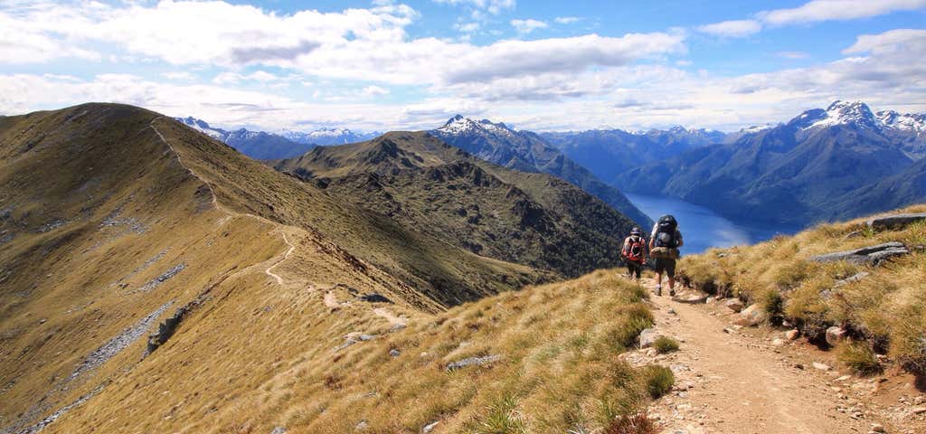
From the beech-forested shorelines of lakes Te Anau and Manapouri, through dense beech forest to tussock-covered ridgelines and spectacular alpine vistas, the Kepler Track is a wilderness adventure above the clouds. The 60km loop takes you up into a spectacular alpine world offering jaw-dropping views of Te Anau and the neighbouring mountain ranges.
It’s one of New Zealand’s Great Walks and a serious hike. The Kepler Track can be walked in either direction. The track is well marked and signposted, but some sections are steep and rough and may be muddy and slippery. Poor weather conditions can make this walk challenging,
Distance: 60 km.
Duration: 3 - 4 days.
It’s important to remember that you will be in an alpine environment, which means there is a good chance you will experience heavy rain, strong winds, snow and freezing temperatures even during the great walk season. So warm and waterproof clothing will be essential, you’ll also need a good pair of hiking boots and make sure you carry enough water for the whole trip.
The track begins with a stroll through the beech forest along the shore of Lake Te Anau, the largest body of fresh water in Australasia, to Brod Bay. Then it’s 8.2 km to Luxmore Hut.
A challenging climb under impressive limestone bluffs takes you above the bushline to panoramic views of the Te Anau Basin and surrounding mountains. Luxmore Hut is a 45 minute walk from the bushline.
A side trip to summit takes 30 minutes return but is well worth it. In fine weather you’ll be rewarded with panoramic views from the highest point on the track (1472 m). The track from the hut is clearly sign posted.
Once back it’s 14.6 km to Burn Hut and usually takes 5 - 6 hours. Start your day on top of the world. From the hut, you’ll climb to a ridge just below Mount Luxmore, with stunning views across the south fiord of Lake Te Anau to the Murchison Mountains. A welcoming sight after a day on the tops, Iris Burn Hut is situated in a large tussock clearing.
The next leg is 16.2 km to Moturau Hut and usually takes 5 - 6 hours.
Experience ever-changing scenery as the track takes you over a low saddle, then down past a large slip caused by heavy rain to Rocky Point. You’ll then wind through a gorge and lowland beech and podocarp forest, before reaching the shore of beautiful Lake Manapouri. The beach-side Moturau Hut has stunning views of the lake.
The last day is easy walking across a unique and fragile wetland to Rainbow Reach and usually takes about 2 hours (6 kms). The track then follows the Waiau River terrace to the swing bridge at Rainbow Reach. You can leave the track here and catch a shuttle bus to Te Anau.
Or hike back to the Kepler carpark, another 9.5 km usually taking between 2.5 and 3.5 hours.
Continue alongside the Waiau River to the Kepler Track car park. Seasonal restrictions
In the Great Walks season (23 October 2018 - 30 April 2019):
- Bookings are required for huts and campsites.
- Huts have gas cooking stoves and resident wardens.
Outside the Great Walks season (1 May 2018 - 22 October 2018):
- Facilities are greatly reduced.
- Avalanche risk exists.
- Experience is required.
- Bookings are not required - huts and campsites are first come, first served.
Getting there:
The Kepler Track starts and finishes at the Kepler Track carpark and is 45 minutes from Te Anau. Start on the lake side path outside the Fiordland National Park Visitor Centre. Passing the Te Anau Wildlife Park, continue around the shores of Lake Te Anau to the Kepler Track carpark near the Lake Te Anau control gates (the large structure that regulate water flows between lakes).
Safety check:
Make sure you check the forecast at MetService.com and talk to the staff at the Te Rua-o-te-moko / Fiordland National Park Visitor Centre before you go.
As with all walks in New Zealand make sure you leave your intentions with a trusted contact too and let them know when you’ve finished. You can find out more about planning your trip at the mountain safety council website.


"Luxmore Hut - Kepler Track" — Photo Credit: Daniel Deans | DOC
Banner Photo Credit: GeoZoneUserId_153977
Explore More Trip Guides
- Trip Guide
The ultimate guide to Mammoth Cave National Park
- 10 Places
- Trip Guide
The Ultimate Guide to Badlands National Park
- 13 Places
- Trip Guide
Route 66 Leg 2: St. Louis to Tulsa
- 61 Places
- 18:31
- 876 mi
- Trip Guide
Route 66 Leg 1: Chicago to St. Louis
- 71 Places
- 16:31
- 636 mi