

A miraculous and rugged, basalt-rimmed bay, Boiler Bay is a great place to watch wild surf action on the rocky spurs. This splendid panoramic viewpoint presents a good opportunity to see gray whales year round. Take your binoculars -- this is one of the best sites in Oregon to see ocean-going birds (like shearwaters, jaegers, albatrosses, grebes, pelicans, loons, oystercatchers and murrelets). In 1910, an explosion sank the J. Marhoffer, and you can see the ship's boiler at low-tide.
Precariously perched on the edge of towering Cape Foulweather nearly 500 feet above the crashing waves, the historic structure known as The Lookout was named to the National Register of Historic Places in January 2015. The Lookout was built in 1937, shortly after the completion of the numerous bridges that made auto travel possible along the Oregon Coast Highway (US 101). Originally known as the Foulweather Coffee Shop, proprietors Wilbur and Anna Badley soon recognized the opportunity of selling souvenirs to travelers and for many years The Lookout was operated as a gift shop. The Lookout was purchased by Oregon State Parks in late 2013 and it continues to be operated as a gift shop with Parks' personnel also on hand to offer interpretive information and help visitors spot whales that are frequently seen from this spectacular viewpoint. The Lookout is located just off the highway at Otter Crest State Scenic Viewpoint four miles south of Depoe Bay.
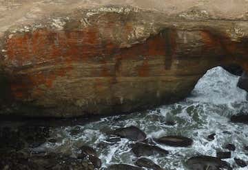
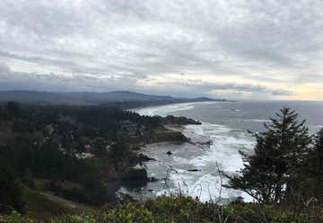
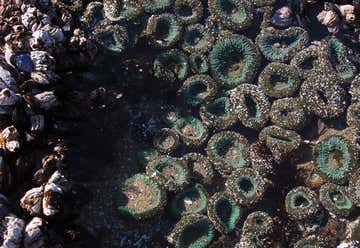
Surfers and surf watchers energize this area! During winter storms, water from the restless ocean slams with a thundering roar into a hollow rock formation shaped like a huge punch bowl. The surf churns, foams, and swirls as it mixes a violent brew. The punch bowl was probably created by the collapse of the roof over two sea caves, then shaped by wave action. The park is a popular whale watching site and displays an intriguing geology. This is a scenic picnic spot atop the undulating rocky shoreline. Don't forget to explore the tidepools on the north side of the punch bowl! Devils Punch Bowl State Natural Area is a state day use park on the central Oregon Coast in the United States. It is centered on a large bowl naturally carved in a rock headland which is partially open to the Pacific Ocean. Waves enter the bowl and often violently churn, swirl, and foam. Outside the bowl, ocean conditions are attractive to surfers near a large offshore rock pinnacle named Gull Rock, located about 1⁄2 miles (800 m) west-northwest of Devils Punch Bowl, which funnels and concentrates waves easily seen from the park. There are at least seventeen large rocks, part of Oregon Islands National Wildlife Refuge, which provide interesting wave viewing, and attract and provide a home for wildlife. Devils Punch Bowl is located about 8 miles (13 km) north of Newport, in the community of Otter Rock, and about 1⁄4 miles (400 m) west of U.S. Route 101. The park encompasses 5.34 acres (2 ha), which includes picnic grounds. There is a trail for access to the beach, and tide pools. The bowl is thought to have been created when two caves carved by the ocean collapsed. Whales migrate past the park, in season, and the park, which projects into the Pacific, provides panoramic views of the ocean and good whale watching.
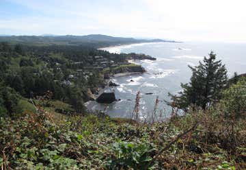
Soak in the view from 500' above the ocean on the breathtaking crescent sweep of white sandy beach stretching to the south. Cape Foulweather is stunning and inspirational with its picturesque panoramic views. This popular whale watching spot also provides a good view of the Devil's Punchbowl.

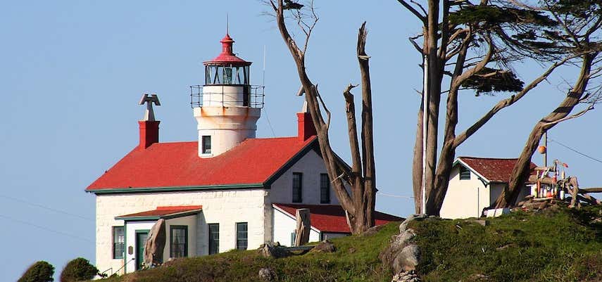
Yaquina Bay lighthouse was built in 1871, but is no longer in use today. Due to this, a few ghost stories have been told about this particular lighthouse. Visitors can tour the lighthouse itself, as well as a gift shop in its basement and its antique period furniture. Yaquina Bay State Park is located in Newport at the north end of Yaquina Bay near its outlet to the Pacific Ocean. The bluff is forested with spruce and pine, but the real star is the historic lighthouse. The lighthouse -- later used as a Coast Guard Lifeboat Station -- has been restored and is open to the public. Attractions nearby include the historic Newport bayfront, Hatfield Marine Science Center and the Oregon Coast Aquarium.
Seal Rock State Wayside has large off-shore rock formations which are the habitat of seals, sea lions, sea birds and other marine life. The wayside includes interesting tidepools as well as excellent ocean views and a sandy beach. Developed for day-use, the picnic area is in a pleasant stand of shore pine, spruce and salal.
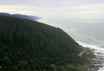
Cape Perpetua is a large forested headland on the central Oregon Coast which projects into the Pacific Ocean. It's part of the Siuslaw National Forest and it is a great place to experience towering trees looming through a coastal fog, frothy surf crashing upon jagged shores, and majestic headlands offering clear views for miles. Cape Perpetua is located 2 miles from Yachats and has a visitor center (Cape Perpetua Visitor Center) that offers a phenomenal view of the ocean from inside and from the deck. A variety of short movies are shown in the theatre, and Center staff can answer questions.
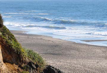
An excellent whale watching and photography viewpoint. Walk the historic 804 Trail (.75 miles one-way with resting benches scattered along the way). The park is known for tidepooling, rock fishing and the yearly smelt run (smelt are small, silvery relatives of salmon). Breathtaking sunsets.
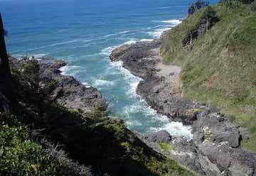
Devils Churn is a narrow inlet of the Pacific Ocean in Lincoln County, Oregon, United States, south of Yachats. It is located in the Siuslaw National Forest and is accessible via the Restless Waters trail[1] from the Cape Perpetua Scenic Area visitor's center or the U.S. Route 101 overlook. Access to the trail requires a United States Forest Service pass. The inlet developed over many thousands of years as wave action carved into the basalt shoreline, first forming a deep sea cave whose roof eventually collapsed. As the tide comes in it can throw spray several hundred feet into the air when the waves reach the end of the churn. Visitors are urged to be cautious when visiting the churn as it can be dangerous.
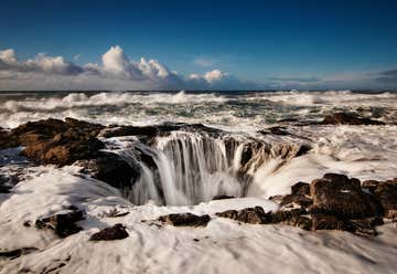
Near Cape Perpetua, Oregon lies one of the most insanely majestic natural wonders in all of America-- a collapsed seacave that has formed a saltwater fountain that's boiling with crashing whitecaps. During high tide, water from the Pacific Ocean rushes into the rocky hole in the coast with a spray of ocean mist. Such a rad natural feature of course has a fittingly awesome name: Thor's Well. I think Odin would approve. Before all you photographers start packing up your gear and heading out to get your own shot of this phenomenon, be warned: getting close to it is no easy feat, especially since the well looks the coolest when conditions are most dangerous-- high tide and during storms. The hole is decievingly deep, 20 feet or more of jagged rock, and you can never tell when an unexpectedly ginormous wave will come surging past the well, knocking down anyone who might be in the way and dragging them out to sea. If you're less of a daredevil and still want to see the well in all its treacherous glory, there's a viewing platform nearby. Taking a hike around the coast will also provide views of other rocky formations like the Spouting Horn, which spurts up a geyser of water when a wave hits it, Cook's Chasm, another natural, wave-powered geyser, and the Devil's Churn, a narrow, rocky inlet where the water violently swirls and tosses. If you head out to see the sights, make sure to wear study shoes-- and be prepared to get wet!

Ten Mile Creek Bridge (No. 01181) is a Conde McCullough-designed bridge near Yachats in Lane County in the U.S. state of Oregon. It was listed on the National Register of Historic Places in 2005. The bridge carries U.S. Route 101 over Tenmile Creek. McCullough designed the structure in 1931. Built of reinforced concrete through a tied arch, the total length of the bridge is with a main span of . Ornate precast concrete railings run along the sides.
The Big Creek Bridge is a bowstring arch bridge that spans the Big Creek on U.S. Route 101 in Lane County, Oregon. It was designed by Conde McCullough and opened in 1931. The bridge has a total length of and contains one reinforced concrete tied arch, identical in design to Ten Mile Creek Bridge and Wilson River Bridge. The locations for all three bridges were similar in that the sandy foundations were not secure enough for the abutment piers required to relieve the lateral pressure of traditional arches. The flood levels of the rivers approached the road grade and ruled out the use of reinforced concrete girders. The corrosive salt air eliminated the practicality of steel truss bridges. The design of the bridge was similar to the rainbow arch design patented by James Barney Marsh. The bridge, along with the Ten Mile Creek Bridge and the Wilson River Bridge, was rehabilitated in 1996 to increase the overhead clearance and add a cathodic protection system to protect the embedded steel reinforcements against the corrosive air. A project to replace the cathodic protection system began in February 2014.
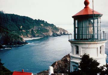
Heceta Head Lighthouse State Scenic Viewpoint is located in a cove at the mouth of Cape Creek, north of Florence. There are picnic tables sheltered from the wind and a great view of the ocean. A short trail leads to the historic Heceta Head lighthouse and assistant keeper's house. Heceta Head trail is part of a 7-mile network. Trails of varying difficulty feature beach and wildlife viewing areas. Wildlife refuge islands feature a view of common murres, cormorants, gulls, and other bird nesting areas. Sea lions and whales can be seen from the beach and cliff-top lighthouse. Named after Don Bruno de Heceta, a Spanish explorer, Heceta Head lighthouse is located north of Florence. This 56-foot tower was first lit in 1894. A half-mile hike will lead visitors to this lighthouse, in addition to seabird nesting sites and nearby Bed and Breakfasts located in the assistant keeper's home. Editor's Tip: The short 1/2 mile hike to the top of the lighhouse from the parking lot is well worth the effort. The spectacular view makes it a great place to share a kiss or for a picnic. In addition, the former keeper's residence located adjacent to the lighthouse functions as a bed & breakfast! Legend has it that at this bed-and-breakfast inn, an old woman’s ghost has been spotted by many. She is said to be the wife of a former lightkeeper.
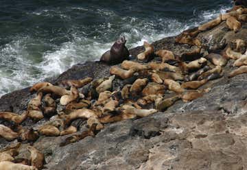
Sea Lion Caves is nature's home for wild sea lions and a variety of sea birds. Sea Lion Caves is located 11 miles North of Florence on the Oregon Coast. The vast cavern with the roar of the great Steller sea lions, the cries of the wailing birds, and the restless surge of the ocean into the cave below, form an unforgettable experience. The cave system is at sea level and the ocean continually washes into the main cavern which has a floor area of about 2 acres (0.81 ha) and a vaulted rock dome about 125 feet (38 m) high. Southward from the main chamber, a low passage runs 1,000 feet (300 m) to a sea level opening. This corridor is flooded at high tide and free of water at low tide. The western entrance is a short, high passage through which the ocean washes at all tide levels. At the north, a third entrance is about 50 feet (15 m) above the ocean which serves as an elevated observation area where the entire underground cave system and its wildlife are visible. Lichens, algae, and mineral stains cover the cavern walls with greens, pinks, purples, buffs, and reds on the rough surfaces some of which are named Lincoln's Head, the Indian Maiden, and The Goddess of Liberty. The sea level portion of this cave and the sea cliff rocks just outside the cave have become, over the centuries, the only known mainland rookery and hauling area (wintering home) of the Stellar Sea Lion and—to a lesser extent—the California Sea Lion. The high vault is a natural resting place for sea birds. Many birds make their home at or near the Sea Lion Caves such as the Pigeon Guillemot, Brandt's Cormorant, Western, Herring, and California Gulls, Tufted Puffins, and the occasional hawk or Bald Eagle. Sea Lion Caves is one of the great sea grottos of the world, comparable in size and coloration to the famed Blue Grotto in the Mediterranean. The whale watching deck, located below the gift shop, permits a seaward view of approximately 20 miles (32 km). The deck is at an elevation of 300 feet (91 m), making it a popular whale watching post. Typically, orcas are seen migrating once a year past the Sea Lion Caves, whereas the Grey Whale is seen anywhere from a few months to all year long. Small groups sometimes end their migration in the immediate vicinity, feeding very close to the shore.
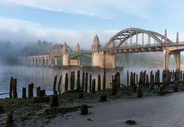
The Siuslaw River Bridge is a bascule bridge that spans the Siuslaw River on U.S. Route 101 in Florence, Oregon. It was designed by Conde McCullough, built by the Mercer-Fraser Company of Eureka, California, and funded by the Federal Emergency Administration of Public Works (later renamed the Public Works Administration). It opened in 1936. The bridge's total length is 1,568 feet (478 m). When open, the 140-foot (43 m) double-leaf bascule provides 110 feet (34 m) of horizontal clearance for boat traffic. The bascule section is flanked by two 154-foot (47 m) reinforced concrete tied arches, identical to those used in the original Alsea Bay Bridge. Four Art Deco-style obelisks house mechanical equipment as well as living quarters for the bridge operator. The total cost of the bridge was $527,000.
Adventure and solitude await you in 40 miles of wind-sculpted, shifting sand dunes! Hiking, paddling, wildlife viewing, camping, picnicking, sand play and beach access - the Oregon Dunes National Recreation Area has it all. While famous for its OHV riding opportunities, the Oregon Dunes also offers many areas for those who are not OHV enthusiasts.

The Umpqua River Bridge is a swing-span bridge that spans the Umpqua River in Reedsport, Oregon. It consists of a central swing span flanked by two reinforced concrete arches on each end. The swing span was necessary to accommodate tall sailing vessels which were common on the Umpqua River. The final cost of the bridge was $510,500. Located at milepoint 211.11 on U.S. Route 101, this bridge is the only remaining swing-span bridge on the Oregon state highway system. This bridge was one of the many bridge projects of Conde McCullough, Oregon's Master Bridge Designer and Builder. It opened to traffic on July 3, 1936. The north end of the bridge is within Bolon Island Tideways State Scenic Corridor; the south is within Reedsport city limits. The bridge was added to the National Register of Historic Places on August 5, 2005. No dedication ceremony occurred at the time due to the unavailability of President Franklin Roosevelt. The ceremony was postponed indefinitely. At 3pm on September 8, 2011, the bridge was opened and closed, followed by a ribbon cutting, and cars from the 1910s, 1920s and 1930s crossed the bridge. It was finally officially dedicated to celebrate its 75th anniversary.

The Port of Bandon is the port authority for Bandon Harbor in the city of Bandon, Oregon, United States.
