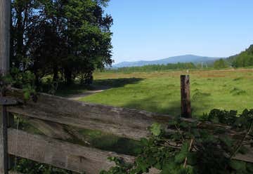
The second day of our Pacific Coast trip.
Kelso, Washington, United States

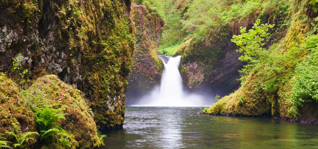
Wah Gwin Gwin Falls (native American: Place of Rushing Waters) is located on the grounds of the Columbia Gorge Hotel (exit 62) in Hood River. One can see the falls easily from an overlook on the grounds -- makes a nice stop if you're driving by.
.JPG)
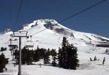
Mount Hood is so majestic that you can see it from all over the Portland area. Two iconic features dominate the mythical landscape of this region: the soaring basalt cliffs forming the tremendous river gorge and the snow-capped peak of the state’s highest volcano. The second most climbed mountain in the world, Mt. Hood is crowned by 11 glaciers and is home to the only year-round ski resort in North America. Elevation: 11,250′ Last eruption: 1907
The Columbia River Gorge National Scenic Area protects the spectacular canyon where the Columbia River cuts through the Cascade mountains - with cliffs and overlooks of Washington to the north and Oregon's mountains and waterfalls to the south. The Gorge is unique in its natural and cultural history, as well as its designation as a National Scenic Area. The Columbia River Gorge, largest national scenic area in the United States, is a land of natural contrasts between rain forest and desert, sea-level passage and alpine meadows. A network of hiking trails climbs from lowland forests to windy ridges on both sides of the Gorge. The river itself hosts the best boardsailing conditions this side of Hawaii, and the nearby snowcaps of Mt. Hood and Mt. Adams offer downhill and cross-country skiing well into spring. Yet the Columbia Gorge is also home to more than 70,000 people, and they've created a rich culture.
There is a trio of Oregon State Parks in the vicinity of Mitchell Point – Seneca Fouts Memorial State Natural Area, Wygant State Natural Area and Vinzenz Lausmann State Natural Area. All three Parks offer great hiking and scenic views overlooking the Columbia River Gorge. The 126 acres that compose Vinzenz Lausmann State Natural Area was donated to the state of Oregon by the family of Vinzenz Lausmann, and named in his memory. At the foot of the park where a trail leads visitors up the steep, rugged slopes of alder, fir and maple is a plaque that honors Mr. Lausmann. The scenic views from this trail are awe-inspiring. The Vinzenz Lausmann State Natural Area is a day use Park and no fee is charged. At this location, the visitor can enjoy hiking and observing mountains, canyons, forests and rock formations.
Hood River Valley, Eastside Road just off Hwy 35, Hood River, OR, US
An easy drive-up viewpoint of the entire picturesque Hood River Valley, this small park is handicapped-accessible and provides parking, restrooms, and picnic tables, so the entire family can relax and soak in the panoramic views from Mt. Hood to Mt. Adams. Park facilities and interpretive signs offer geological history of the Hood River Valley. The view features more than 15,000 acres of orchards and vineyards, and the fruit trees in bloom in spring offer a photo opportunity not to be missed.
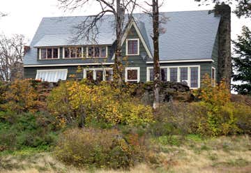
Cliff Lodge is a historic house located in Hood River, Oregon, United States. The house was listed on the National Register of Historic Places in 2000.
Oftentimes overlooked, this 190-ft two-tiered Starvation Creek waterfall is quite impressive, tucked away behind the more-popular rest area. It's directly off I-84, making for a quick stop to take in a bit of history and beauty. Follow the path and signs to the waterfall and a couple of creek-side picnic tables at the base of the falls. Make sure to read the informational panels sharing the story of the waterfall's name. You can continue on the paved Historic Columbia River Highway State Trail for another mile to the east taking you to Viento State Park. This area is also the trailhead for many other hikes including: Starvation Ridge Loop and Mt. Defiance—leading you past many more mysterious and stunning waterfalls.
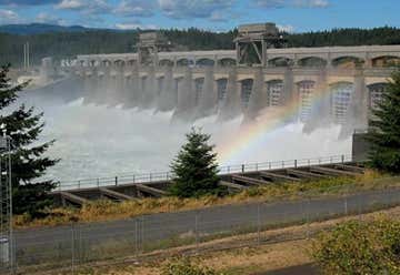
The U.S. Army Corps of Engineers operates and maintains Bonneville Lock and Dam for hydropower production, fish and wildlife protection, recreation, and navigation. Visitors can experience the operation of two hydroelectric powerhouses, watch migrating fish traveling upstream at the underwater viewing rooms next to the fish ladders, and see salmon and sturgeon in the fish hatchery.
Built in 1926, crosses the Columbia River and is a part of the Pacific Crest National Scenic Trail. The bridge is named from a Native American Legend. Don't get it confused with the naturally occurring land bridge by the same name.
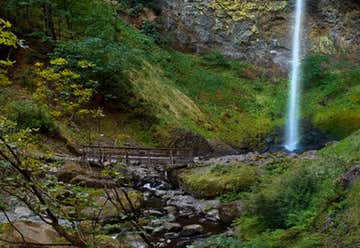
John B. Yeon Scenic Corridor honors a man who gave generously of his time and professional skills. He was one of the principal architects of the Historic Columbia River Highway (US 30); a major portion of the scenic highway joins I-84 westbound at Yeon State Park.Here is a hiker's paradise with a gentle rising trail that permits access to two of the most beautiful and secluded waterfalls in the Columbia River Gorge: (lower) Elowah Falls and (upper) McCord Creek falls. Elowah Falls is a 289 foot drop over basalt that must be seen to appreciate. The view of the falls and way the tall cliffs jut out at odd angles is nearly disorienting at the bottom of the trail. Most days, the trails are never crowded. The crisp air, easy access and accompanying scenery of this area offer some of the best hiking and viewing opportunities available in the Gorge.
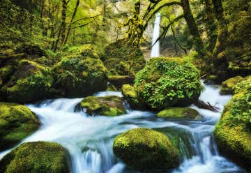
Elowah Falls is one of the hidden gems in the Columbia River Gorge. The falls flow year round, but are best in the late winter and spring, like many others in the area. The cliffs on either side of the falls are flanked with the colorful yellow-green lichen found throughout the Columbia Gorge, adding a lot to the aesthetics of the scene. The falls are usually said to stand 289 feet tall, however repeated visits led us to doubt the validity of that figure. At certain places along the trail to the falls its possible to see Elowah and a part of Upper McCord Creek Falls in tandem, which could have possibly led to the idea that it was one series of waterfalls. Turns out the USGS had sent a survey team to determine the height of the falls in 1916 - their efforts produced a height of 221 feet. We measured the falls in 2009 to be 213 feet tall, so the only way the height of 289 feet could have materialized is if Upper McCord Creek Falls were included. Along the trail to both Elowah and Upper McCord Creek Falls can be seen several sections of old cast iron and wooden pipes which were used to flume pressurized water water to the Crown Willamette Paper Company mill along the Columbia River. Elowah Falls is somewhat similar in appearance to Latourell Falls. The hike begins along the Gorge Trail (#400). Keep left at the first junction, then left again at the second junction (in 0.2 miles). This short, not overly difficult hike will bring you to a bridge over McCord Creek right at the base of the falls, where you can watch the dramatic waterfall plunge 228 ft. right in front of you. If you go right at the second junction onto the Elowah Falls Trail, you will come to another great viewpoint of Elowah Falls, near the top of the waterfall. This Elowah Falls Trail also continues up to Upper McCord Creek Falls. Elowah Falls is commonly cited as being 289 ft. high. It is not nearly this tall. My measurement was 228 ft. (which is close to Bryan Swans measurement of 213 ft.). I suspect the 289 ft. measurement includes Upper McCord Creek Falls in the height, which is a short distance upstream of Elowah.
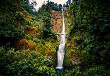
Multnomah Falls is a waterfall on the Oregon side of the Columbia River Gorge, located east of Troutdale, between Corbett and Dodson, along the Historic Columbia River Highway. The falls drops in two major steps, split into an upper falls of 542 feet (165 m) and a lower falls of 69 feet (21 m), with a gradual 9 foot (3 m) drop in elevation between the two, so the total height of the waterfall is conventionally given as 620 feet (189 m). Multnomah Falls is the tallest waterfall in the State of Oregon. It is credited by a sign at the site of the falls as the second tallest year-round waterfall in the United States but that claim is debated among waterfall experts. Underground springs from Larch Mountain are the year-round source of water for the waterfall, augmented by spring runoff from the mountain's snow-pack and rainwater during the other seasons. A foot trail leads to Benson Footbridge, a 45-foot (14 m)-long footbridge that allows visitors to cross 105 feet (32 m) above the lower cascade. The trail continues to a platform at the top of the upper falls where visitors get a bird's-eye view of the Columbia Gorge and also of "Little Multnomah", a small cascade slightly upstream from the "upper" falls, which is not visible from ground level. The footbridge is named for Simon Benson, who financed the bridge's construction in 1914 by Italian stonemasons. According to legend, "There was a terrible sickness that threatened lives of the Multnomah people. An old medicine man revealed that the sickness had been foretold but that it would pass if a maiden descendant of a tribal chief would throw herself from a high cliff above the big river and onto the rocks below. The chief was not willing to sacrifice any of his daughters, so he elected to allow the sickness to run it’s course.When the Chief’s daughter saw that the sickness had affected her lover, she went up to the top of the cliff and threw herself to the rocks below. Upon her death, the sickness immediately began to leave the affected people. Now, when the breeze blows through the water, a silvery stream separates from the upper falls.
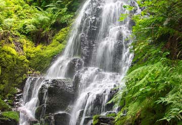
Fairy Falls is a 20-foot waterfall on the Oregon side of the Columbia River Gorge in the United States. As part of a tributary of Wahkeena Creek, Fairy Falls is located upstream from the much larger Wahkeena Falls. While small, this fan-shaped waterfall is a destination for photographers, mainly because of the scenic view. The creek cascades through a mossy rock slide lined with ferns, until rocky ledges of basalt break the water into various lacy streams.
Wahkeena Falls is a 242 foot (73 m) waterfall in the Columbia River Gorge in the state of Oregon. The waterfall is unlike nearby Multnomah Falls in that the water does not directly plunge to the ground. Wahkeena Falls, rather, has a more subtle cascading flow. These falls have been featured in numerous travel guides and in photography books. Spellings of this name are dubious because the word is an English transliteration of a Native American (reportedly Yakama) phrase meaning most beautiful. Wahkeena Falls is along the Historic Columbia River Highway, about 13 miles (21 km) east of Troutdale, Oregon. A 0.2-mile (320 m) hike from the parking lot at the base leads to the stone bridge that crosses the main part of the falls. That trail continues on east to Multnomah Falls, the next falls to the east. This waterfall is visible directly from the Historic Columbia River Highway.
Bridal Veil Falls State Park is located near milepost 28 on the Historic Columbia River Scenic Highway and is accessed off I-84 at Exit 28. Travel west on the Historic Columbia River Highway about 3/4 of a mile to the entrance of Bridal Veil Falls State Park. The park offers a nice parking area, picnic tables and restrooms all within easy walking distance from the parking area. Nice grassy areas afford visitors a chance to stretch a blanket in one of the laziest parts of the Columbia River Gorge. The park is situated in large timber stands; the area was a natural choice as a logging haven once upon a time. The park features two different trails: an upper walking/interpretive trail and a lower hiking trail to the falls (120' tall). Both are not to be missed. The upper trail takes visitors around the precipice of the cliffs of the Gorge. Sign boards along the trail point out distinctive native wild plants that grow abundantly in this area such as camas, lupine, bead lilly, trillium and bleeding heart. The trail is fenced beautifully with logged beams and wire to protect visitors along the viewpoint while maximizing every vantage point of the magnificent view of the Gorge. The famous geologic edifice known as the Pillars of Hercules, a 120-foot basalt tower once used as a training site for mountain climbing, can be seen best from the upper trail at Bridal Veil. The lower trail at Bridal Veil takes the visitor downhill to the base of Bridal Veil Falls and is about a mile round trip to the falls and back. Although short, this is a steep little trail full of switchbacks and is not wheelchair accessible. Along the way are a few unwanted wild plants of this area -- such as poison oak -- so keep on the path. Do not attempt to walk along the bridge over the Historic Highway to view the falls. The road here is a narrow two-lane passage with absolutely no sidewalk. PLEASE view the falls from the trail.Beautiful Bridal Veil Falls is an elegant and graceful lady that can be fully appreciated from the deck of a viewing platform rebuilt in 1996. The creek hustles down from the top of nearby Larch Mountain, tumbles over the cliff and eventually flows into the mighty Columbia River. No visit to the Columbia Gorge should be considered complete without a tour of the area of Bridal Veil and a visit to Bridal Veil Falls State Park.
The view is absolutely breathtaking and it's one of the best spots to soak in a view of one of the most beautiful places on earth: the magnificent, awesome Columbia River Gorge. Any visit to the Gorge would be nearly perfect with Women's Forum as the starting place to a fun-filled day of adventure and discovery. With the scenic Vista House and the wide expanse of the Columbia Gorge in the background, more photographs of the Columbia Gorge are probably taken from this point than anywhere else (but don't let that stop you ... go ahead and take a few shots of your own).
Located at the western gateway of the Columbia River Gorge, Lewis & Clark State Park appropriately honors its legendary namesakes who camped and explored here in November, 1805. The park is situated near the mouth of the Sandy River where it spills into the mighty Columbia River and at one of the entrances to the Historic Columbia River Highway. A flat, grassy, tree-dotted park invites blankets and sun-lovers to come spend a leisurely day. One of the most popular swimming spots on the Sandy River is adjacent to the park, as well as a public boat launch. A trail climbs the cliffs to Broughton's Bluff, which serves as a geologic boundary between the foothills of the Cascade Mountain Range and the neighboring Willamette Valley to the west.
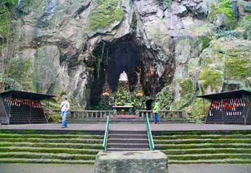
This beautiful 62-acre Catholic shrine and botanical garden is located in Portland, Oregon. “The Grotto” is the popular name of The National Sanctuary of Our Sorrowful Mother. It is a non-profit organization supported solely by the proceeds of its gift shop and by donations. It is administered by the Order of Friars Servants of Mary, USA Province. The Grotto strives to provide a welcoming presence and a beautiful environment conducive to peace, quiet, and spiritual inspiration. The Grotto offers understanding, compassion, support and hope through a variety of ministries including counseling, education, spiritual direction and liturgical celebrations. The Grotto endeavors to serve all people. With its fir trees, colorful rhododendrons and other native plants, The Grotto is an inviting destination for all. An internationally-renowned Catholic shrine and botanical garden, The Grotto provides a spiritual and peaceful retreat for more than 200,000 visitors each year from all faiths and all walks of life. Visitors are delighted to discover this 62-acre green space just minutes from downtown Portland. The heart of the shrine is Our Lady’s Grotto, a rock cave carved into the base of a 110-foot cliff. A life-size marble replica of Michelangelo’s Pietà is featured in its center. The Grotto’s Chapel of Mary, Gift Shop, Conference Center and Visitor Complex are located on the plaza level with Our Lady’s Grotto. On The Grotto’s upper level, visitors are delighted to discover the manicured gardens, religious artwork, and beautiful panoramic views of the Columbia River Valley, the Cascades and Mt. St. Helens. Also on the upper level are the cliff side Meditation Chapel and the Servite Monastery. In addition to its beautiful gardens, The Grotto offers comfort, support, and healing through The Grotto Counseling Center and The Grotto Spirituality Program.
